
Iceland Volcano: Updated Hazard Map For The Grindavík – Svartsengi Region -- Iceland Met Office
Categories
Edited | All Content | Front Page Stories | Disasters | Earthquakes | Volcanos | Government | Science | North America | Europe | Atlantic Ocean | News | Analysis | News -- WNT Selected
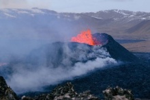
Sundhnúksgígar continues to be the prime location for an eruption
Information is updated regularly here and on X (Formerly known as Twitter).
Updated 5 January at 17:40 UTC (2:40 p.m. EST)
A new hazard map has been issued by IMO. The map reflects a hazard-based appraisal of the Grindavík – Svartsengi region, made on 5 January 2024. The hazard assessment is based on the latest monitoring data, including seismic activity and ground deformation, as well as geodetic modeling results. The assessment also takes into consideration the likelihood of volcanic hazards in each of the six zones, as shown on the map.
In today's assessment, the main change affects the Svartsengi region (zone 1), which is now considered to be at a moderate hazard level, reflecting a decrease from the previous version of the hazard map. The justification for this change is that the hazard rating due to the formation of major surface fractures has decreased as no new major fractures have formed lately. Additionally, the latest geophysical observations, together with our scientific consensus, make Sundhnúksgígar the prime location for an eruption.
In the meantime, IMO continues to monitor the area and any changes will be communicated directly to civil protection via the usual communication channels.

- CreatedFriday, January 05, 2024
- Last modifiedSaturday, January 06, 2024
SUBSCRIBE
Sign up for our weekly newsletter and World News Trust project updates.

World Desk Activities

cpj.org/resources-for-journalists-covering-protest…

cpj.org/2020/09/guide-to-legal-rights-in-the-u-s/

pressfreedomtracker.us/submit-incident/

drive.google.com/file/d/17XyVCVOTq59bvTEG_RZAQMgrF…

www.icfj.org/news/new-icfj-knight-fellows-work-sup…

U.S.Justice Department: "Radical Right vs. Radical Left: Terrorist Theory and Threat"
www.ojp.gov/ncjrs/virtual-library/abstracts/radica….
ijnet.org/en/story/tips-building-networks-reach-au…

trustingnews.org/how-trustworthy-is-your-newsroom-…

Latest Stories


Electronic Frontier Foundation
- EFF to Court: Electronic Ankle Monitoring Is Bad. Sharing That Data Is Even Worse. May 17, 2024
- EFF Urges Ninth Circuit to Hold Montana’s TikTok Ban Unconstitutional May 17, 2024
- Fair Use Still Protects Histories and Documentaries—Even Tiger King May 15, 2024
- The Cybertiger Strikes Again! EFF's 8th Annual Tech Trivia Night May 15, 2024
The Intercept
- The State Department Says Israel Isn’t Blocking Aid. Videos Show the Opposite. May 18, 2024
- Medical Workers Evacuated From Gaza, but 3 Americans Refuse to Leave May 17, 2024
- An Israeli Company Is Hawking Its Self-Launching Drone System to U.S. Police Departments May 17, 2024
- The Consumer Finance Protection Bureau Is Constitutional, After All May 16, 2024
VTDigger
- Paul R. Philbrook May 17, 2024
- Amid criticism, postal service pauses plans to restructure facilities in White River Junction and Burlington May 17, 2024
- State intends to build new secure juvenile facility in Vergennes May 17, 2024
- Anti-abortion groups spar in court with state lawyer over crisis pregnancy centers May 17, 2024
