
Iceland Volcano: Increased Likelihood Of Volcanic Eruption -- Iceland Met Office
Categories
Edited | All Content | Disasters | Earthquakes | Volcanos | Government | Science | Europe | Atlantic Ocean | News -- WNT Selected
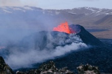
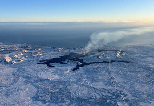 Lava from the eruption 8 February 2024. Photo: Birgir Vilhelm Óskarsson/The Icelandic Institute of Natural History.
Updated hazard assessment. Zones 2 and 3 have been merged into one zone
Information is updated regularly here and on X (Formerly known as Twitter).
Updated 7 March at 17:00 UTC
Likely sequence of events over the next several days:
- The volume of magma beneath Svartsengi continues to increase, which could result in a new dike intrusion and possibly an eruption.
- An eruption could occur with very short notice, possibly less than 30 minutes.
- The most likely eruption site is between Stóra-Skógafell and Hagafell.
Seismic activity associated with the volcanic unrest has been decreasing since Saturday, with very few earthquakes detected in the past few days. However, unfavorable weather conditions have disrupted seismic monitoring by dampening small events, so there have likely been additional minor earthquakes that could not be detected.
Weather conditions over the next 24 hours will likely hinder the Meteorological Office's earthquake monitoring system. The forecast indicates that Reykjanes will experience strong winds from the southeast accompanied by rain and limited visibility, especially in mountainous regions. Precipitation will decrease in the early morning, with occasional showers coinciding with reduced visibility expected tomorrow and the following days. Winds are expected to decrease over the weekend, coming from the southeast or northwest on Sunday.
Inflation continues at Svartsengi, and model calculations based on GNSS data from March 3rd to 6th indicate that approximately 1.2 million cubic meters of magma has been injected into the magma chamber during these days. Therefore, approximately 10 million cubic meters of magma has accumulated in the magma chamber overall since the last eruption. The current situation is therefore similar to what it was before the eruption on March 2nd.
Updated hazard assessment
The Meteorological Office has updated the hazard assessment map. The hazard level remains unchanged from the last map. One change has been made to the zoning; Zones 2 and 3 have been merged into one single zone. Given the development of the activity, there is no longer a reason to assess the risk in these areas separately. The new hazard assessment map took effect at 3 p.m. today, Thursday, March 7. This hazard assessment is valid until March 12, barring any changes to the situation.
 (Click on the map to see it larger)
- CreatedThursday, March 07, 2024
- Last modifiedWednesday, March 13, 2024
SUBSCRIBE
Sign up for our weekly newsletter and World News Trust project updates.

World Desk Activities

cpj.org/resources-for-journalists-covering-protest…

cpj.org/2020/09/guide-to-legal-rights-in-the-u-s/

pressfreedomtracker.us/submit-incident/

drive.google.com/file/d/17XyVCVOTq59bvTEG_RZAQMgrF…

www.icfj.org/news/new-icfj-knight-fellows-work-sup…

U.S.Justice Department: "Radical Right vs. Radical Left: Terrorist Theory and Threat"
www.ojp.gov/ncjrs/virtual-library/abstracts/radica….
ijnet.org/en/story/tips-building-networks-reach-au…

trustingnews.org/how-trustworthy-is-your-newsroom-…

Latest Stories


Electronic Frontier Foundation
- Fair Use Still Protects Histories and Documentaries—Even Tiger King May 15, 2024
- The Cybertiger Strikes Again! EFF's 8th Annual Tech Trivia Night May 15, 2024
- Coalition to Calexico: Think Twice About Reapproving Border Surveillance Tower Next to a Public Park May 14, 2024
- One (Busy) Day in the Life of EFF’s Activism Team May 14, 2024
The Intercept
- The Consumer Finance Protection Bureau Is Constitutional, After All May 16, 2024
- Outside Groups Spent $285,000 Backing Jamaal Bowman. AIPAC Alone Just Dropped Nearly $2 Million to Attack Him. May 16, 2024
- Republicans Can't Decide: Do They Hate Prosecutors Because of Bail Reform or Abortion? May 16, 2024
- University Professors Are Losing Their Jobs Over “New McCarthyism” on Gaza May 16, 2024
VTDigger
- Drew Lalumiere May 16, 2024
- Robert Howard Rodgers May 16, 2024
- Former executive for medical records firm gets probation for trying to obstruct opioid kickback probe May 16, 2024
- Winooski deputy mayor announces bid for lieutenant governor May 16, 2024
