
Iceland Volcano: Continued Increased Likelihood Of An Eruption -- Iceland Met Office
Categories
Edited | All Content | Disasters | Earthquakes | Volcanos | Government | Science | Europe | Atlantic Ocean | News | News -- WNT Selected
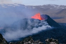
 Lava from the eruption 8 Feb. 2024. Photo: Birgir Vilhelm Óskarsson/The Icelandic Institute of Natural History.
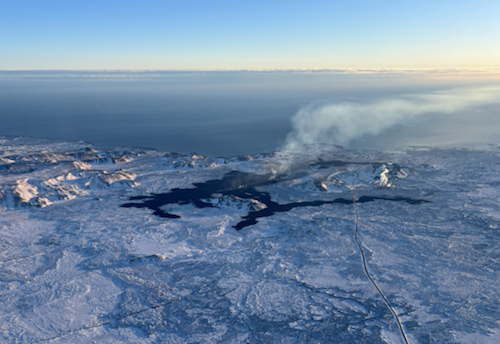
Magma continues to accumulate beneath Svartsengi
Information is updated regularly here and on X (Formerly known as Twitter).
Updated 3. March at 12:15 UTC
Likely scenario over the next few days
- Magma volume beneath Svartsengi continues to increase, which could lead to another magma propagation and even a volcanic eruption.
- A volcanic eruption could start with a very short warning time, even less than 30 minutes.
- A volcanic eruption is most likely to occur in the area between Mt. Stóra-Skógfell and Mt. Hagafell.
The Icelandic Meteorological Office has updated the hazard assessment map due to the decrease in seismic activity in the Reykjanes peninsula.
Considering the developments in activity since yesterday, the hazard level has been lowered in two zones -- Zones 2 and 3. The hazard level remains unchanged in other areas, thus the hazard assessment is now the same as it was before yesterday‘s event.
The hazard assessment map is valid from 13:00 UTC today, 3 March, until 15:00 Tuesday 5 March unless development in activity call for a re-evaluation.
 (Click on the map to see it larger)
Updated 3. March at 11:50 UTC
Seismic activity at Mt. Sýlingarfell was due to a magma intrusion. The seismic activity started around 16:00 UTC yesterday (2 March) and subsided steadily after 18:00 and after 20:00 it was mostly over.
Data indicate that yesterday‘s magma intrusion has stopped by Mt. Hagafell. The likelihood of magma ascending in relation to this magma intrusion has decreased but the area continues to be closely monitored for this possibility.
Model calculations indicate that the volume of magma that propagated out of Svartsengi yesterday was negligible compared with previous magma propagations which culminated with an eruption.
Therefore, it can be assumed that magma accumulation beneath Svartsengi is continuing as before and that the volume of magma that has already been accumulated suffices to trigger another magma propagation. It can be expected that another magma propagation can occur in the next few days and there continues to be an increased likelihood of an eruption, as before yesterday‘s event.
This depends on how quickly the pressure caused by magma accumulation under Svartsengi builds up to trigger another magma propagation.
Considering these developments, The Icelandic Meteorological Office is working on a new hazard assessment map which will be updated in the coming hours.
Likely scenarios over the next few days:
- Magma volume beneath Svartsengi continues to increase, which could lead to another magma propagation and even a volcanic eruption.
- A volcanic eruption could start with a very short warning time, event less than 30 minutes.
- A volcanic eruption is most likely to occur in the area between mt. Stóra-Skógfell and mt. Hagafell.
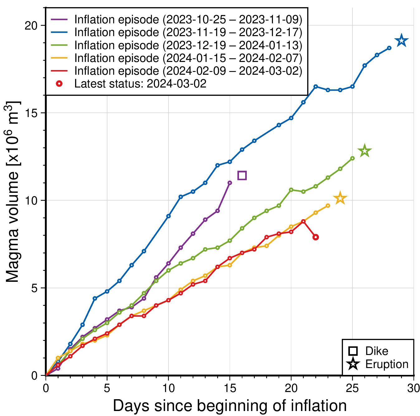 The graph shows a comparison of volume of magma accumulated beneath Svartsengi before it propagates towards Sundhnúkur crater row. The status of the magma volume at 2 March after the magma propagation are indicated with red color. The amount is derived through model calculations based on GPS data and subject to uncertainties. Changes can vary from day to day, from being small to more prominent changes. The purple line shows the magma volume accumulated before the large diking event beneath Grindavík formed on the 10 Nov. 2023.
- CreatedSunday, March 03, 2024
- Last modifiedTuesday, March 05, 2024
SUBSCRIBE
Sign up for our weekly newsletter and World News Trust project updates.

World Desk Activities

cpj.org/resources-for-journalists-covering-protest…

cpj.org/2020/09/guide-to-legal-rights-in-the-u-s/

pressfreedomtracker.us/submit-incident/

drive.google.com/file/d/17XyVCVOTq59bvTEG_RZAQMgrF…

www.icfj.org/news/new-icfj-knight-fellows-work-sup…

U.S.Justice Department: "Radical Right vs. Radical Left: Terrorist Theory and Threat"
www.ojp.gov/ncjrs/virtual-library/abstracts/radica….
ijnet.org/en/story/tips-building-networks-reach-au…

trustingnews.org/how-trustworthy-is-your-newsroom-…

Latest Stories


Electronic Frontier Foundation
- EFF to Court: Electronic Ankle Monitoring Is Bad. Sharing That Data Is Even Worse. May 17, 2024
- EFF Urges Ninth Circuit to Hold Montana’s TikTok Ban Unconstitutional May 17, 2024
- Fair Use Still Protects Histories and Documentaries—Even Tiger King May 15, 2024
- The Cybertiger Strikes Again! EFF's 8th Annual Tech Trivia Night May 15, 2024
The Intercept
- The State Department Says Israel Isn’t Blocking Aid. Videos Show the Opposite. May 18, 2024
- Medical Workers Evacuated From Gaza, but 3 Americans Refuse to Leave May 17, 2024
- An Israeli Company Is Hawking Its Self-Launching Drone System to U.S. Police Departments May 17, 2024
- The Consumer Finance Protection Bureau Is Constitutional, After All May 16, 2024
