
Iceland Volcano: Increased Likelihood Of An Eruption (Update) -- Iceland Met Office
Categories
Edited | All Content | Disasters | Earthquakes | Volcanos | Government | Science | Europe | Atlantic Ocean | News | News -- WNT Selected
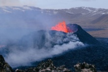
 Lava from the eruption 8 February 2024. Photo: Birgir Vilhelm Óskarsson/The Icelandic Institute of Natural History.
Weather conditions over the next few days could affect the Iceland Met Office monitoring system. Hazard assessment unchanged.
Information is updated regularly here and on X (Formerly known as Twitter).
Updated 5 March at 14:20 UTC
Likely scenarios over the next few days:
- The volume of magma within the Svartsengi reservoir continues to increase, which could result in a new dike propagation and/or volcanic eruption in the coming days.
- A volcanic eruption could start with a very short warning time, even less than 30 minutes.
- It is most likely that an eruption will occur in the area between Mt. Stóra-Skógfell and Mt. Hagafell.
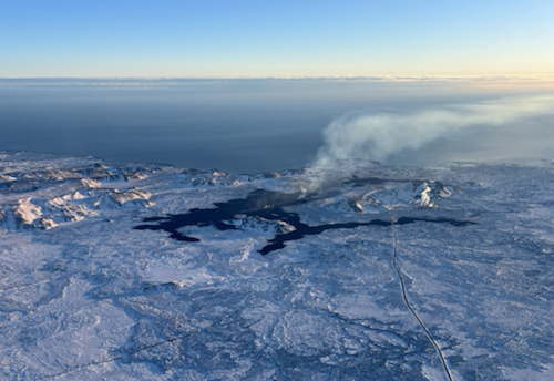
Seismicity over the dike has been low since the magma propagation ended on Saturday (2 March) evening. There is slightly more activity at Mt. Fagradalsfjall, where around 20 earthquakes have been detected in the last 24 hours.
Model calculations indicate a volume loss of about -1.3 million cubic metres from the Svartsengi magma reservoir on Saturday – which fed a 3-km long dike intrusion between Mt. Stóra-Skógfell and Mt. Hagafell. The volume loss from the Svartsengi reservoir was much lower than that which occurred during previous events, where a volume loss of about -10 million cubic metres was calculated.
Continuous land uplift is detected on GNSS observations since Saturday‘s magma propagation. Magma inflow beneath Svartsengi thus continues and model calculations suggest an inflow/accumulation rate of about half a million cubic metres per day. In total, about 9,5 million cubic metres of magma has been recharged to the reservoir beneath Svartsengi since the eruption on 8-9 February.
Therefore, pressure in the magma reservoir continues to build up, and there is an increased likelihood of another dike propagation within the Sundhnúkur crater row and/or a volcanic eruption in the coming days.
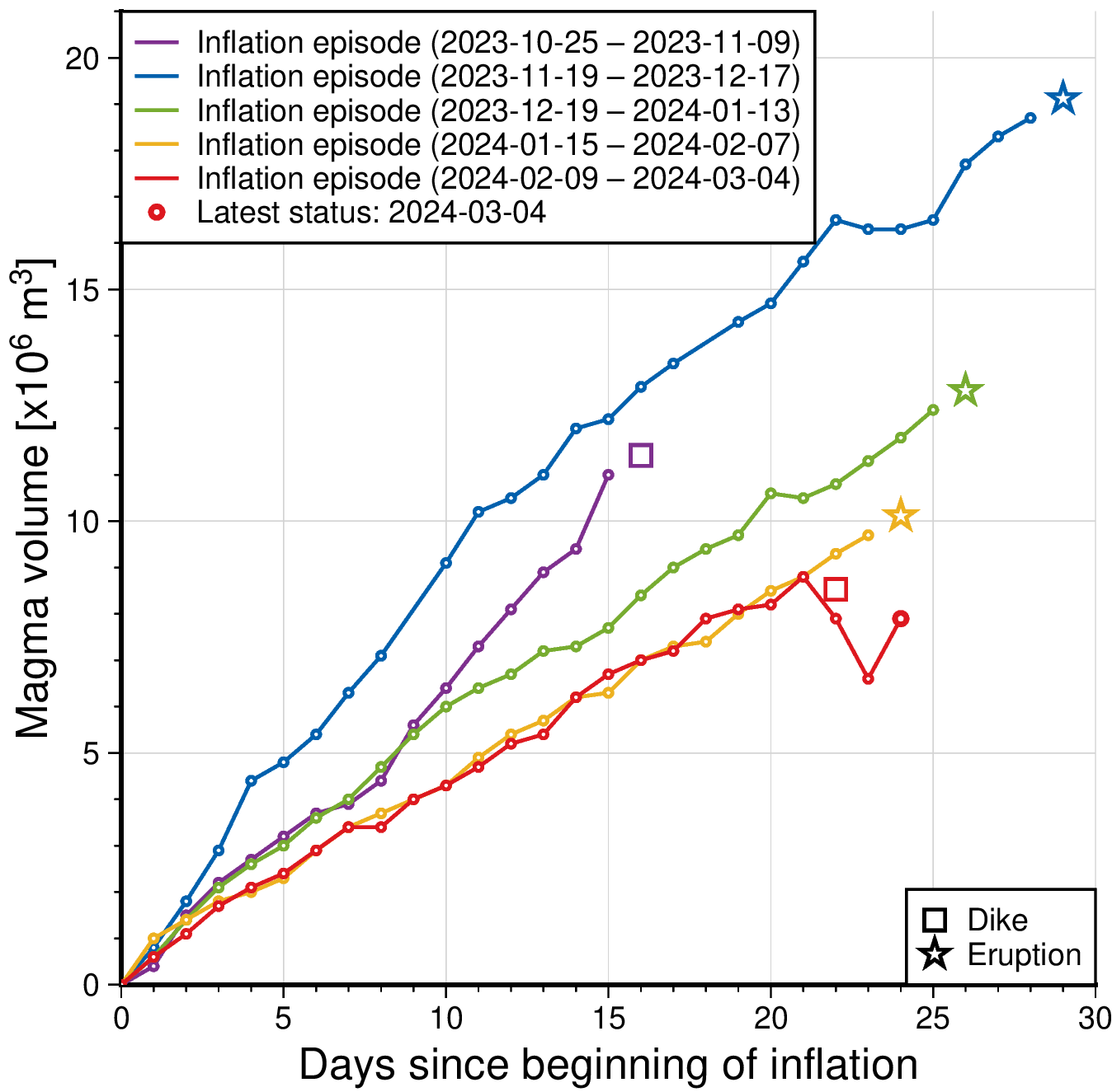 The graph shows a comparison of volume increase within the Svartsengi reservoir before dike propagations and/or eruptions. The status of the volume change as of 4 March is indicated by the red line. This line also shows what effect the magma propagation on the 2 March had on the accumulation process within the magma reservoir beneath Svartsengi. The quantities displayed on this graph are derived from model calculations based on GNSS data alone. Joint InSAR-GNSS modelling of the diking event on Saturday indicates a volume loss of about -1.3 million cubic metres from the Svartsengi reservoir which fed the dike propagation within the Sundhnúkur crater row, without resulting in an eruption. Values derived from both the GNSS only and the joint InSAR-GNSS inversions are subject to uncertainty.
Weather conditions might affect IMO‘s monitoring systems
The weather over the next few days is likely to affect the monitoring systems. The forecast for the week is southeasterly and easterly winds, around 10-15 m/s. Rain showers most days with increasing wind speeds and more calmer winds in between showers.
 The Icelandic Meteorological Office has updated the hazard assessment map, which is unchanged from the previous hazard assessment. The new hazard assessment is valid until Thursday, 7 March, unless developments in activity call for a re-evaluation.
- CreatedTuesday, March 05, 2024
- Last modifiedThursday, March 07, 2024
SUBSCRIBE
Sign up for our weekly newsletter and World News Trust project updates.

World Desk Activities

cpj.org/resources-for-journalists-covering-protest…

cpj.org/2020/09/guide-to-legal-rights-in-the-u-s/

pressfreedomtracker.us/submit-incident/

drive.google.com/file/d/17XyVCVOTq59bvTEG_RZAQMgrF…

www.icfj.org/news/new-icfj-knight-fellows-work-sup…

U.S.Justice Department: "Radical Right vs. Radical Left: Terrorist Theory and Threat"
www.ojp.gov/ncjrs/virtual-library/abstracts/radica….
ijnet.org/en/story/tips-building-networks-reach-au…

trustingnews.org/how-trustworthy-is-your-newsroom-…

Latest Stories


Electronic Frontier Foundation
- EFF to Court: Electronic Ankle Monitoring Is Bad. Sharing That Data Is Even Worse. May 17, 2024
- EFF Urges Ninth Circuit to Hold Montana’s TikTok Ban Unconstitutional May 17, 2024
- Fair Use Still Protects Histories and Documentaries—Even Tiger King May 15, 2024
- The Cybertiger Strikes Again! EFF's 8th Annual Tech Trivia Night May 15, 2024
The Intercept
- The State Department Says Israel Isn’t Blocking Aid. Videos Show the Opposite. May 18, 2024
- Medical Workers Evacuated From Gaza, but 3 Americans Refuse to Leave May 17, 2024
- An Israeli Company Is Hawking Its Self-Launching Drone System to U.S. Police Departments May 17, 2024
- The Consumer Finance Protection Bureau Is Constitutional, After All May 16, 2024
