
Iceland Volcano: Increased Likelihood Of Volcanic Eruption In Coming Days -- Iceland Met Office
Categories
Edited | All Content | Earthquakes | Volcanos | Government | Science | Technology | Europe | Atlantic Ocean | News | News -- WNT Selected
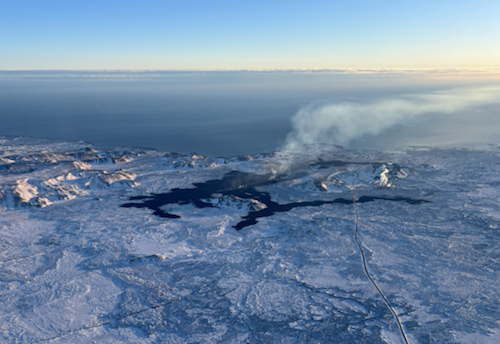 Lava from the eruption 8. February 2024. Photo: Birgir Vilhelm Óskarsson/The Icelandic Institute of Natural History.
Raised hazard levels in an updated hazard assessment
Information is updated regularly here and on X (Formerly known as Twitter).
Updated 27. February at 13:00 UTC
- Accumulated magma beneath Svartsengi is reaching the same amount as before previous eruptions.
- An eruption could start with very little warning time, even less than 30 minutes.
- Hazard levels have been raised in an updated hazard assessment due to impending eruption.
- An eruption is most likely in the area between Mt. Stóra-Skógfell and Mt. Hagafell.
- The hazard assessment does not account for weather conditions or other factors that may affect the risk of being within the hazard zones.
- A dike intrusion may occur without resulting in a volcanic eruption.
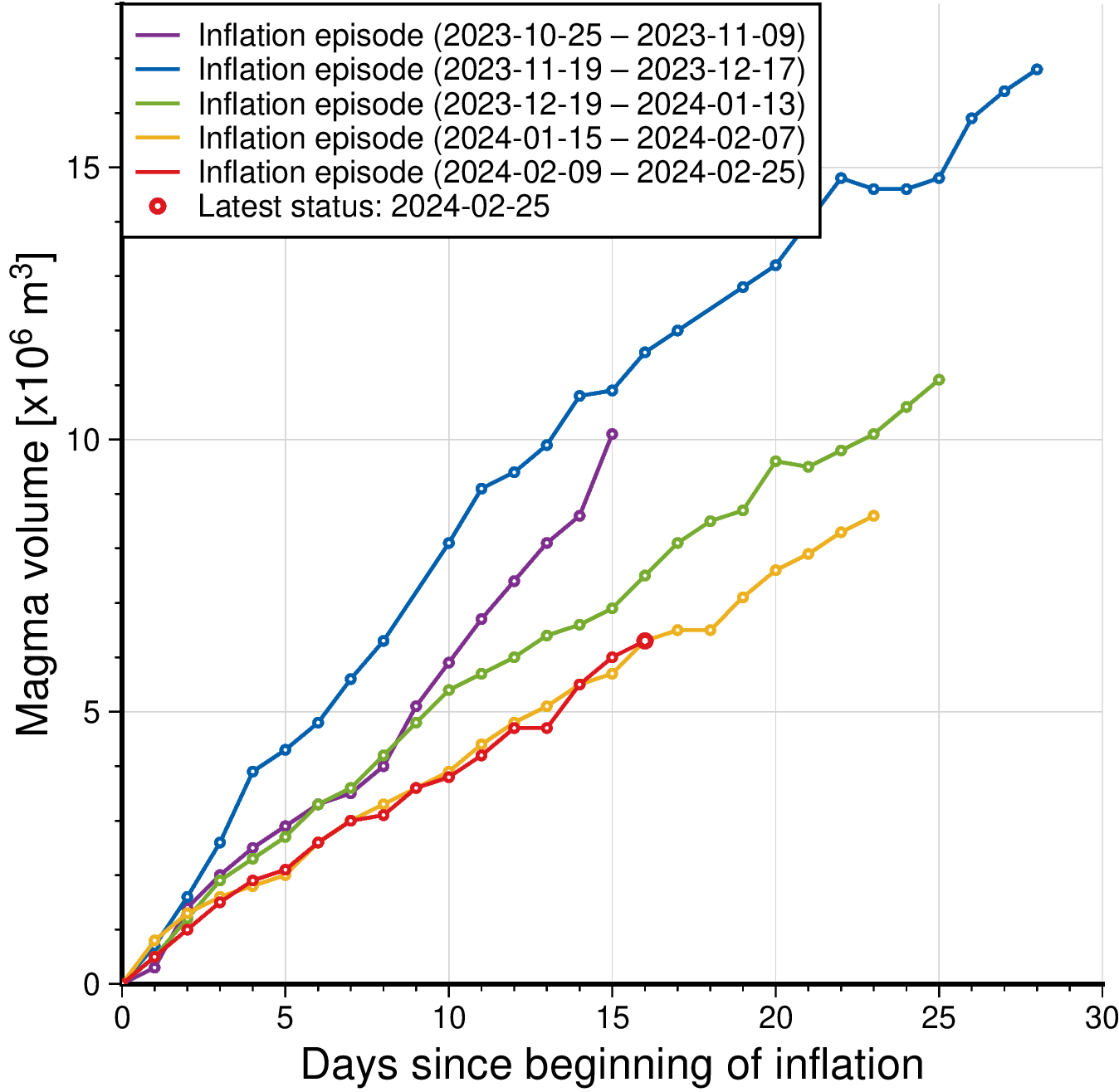
Model calculations suggest that about 7.6 million m3 of magma has been recharged within the Svartsengi reservoir. Considering precursors of previous volcanic eruptions in the Sundhnúkar crater row, the likelihood of a volcanic eruption increases once the volume of magma reaches 8 – 13 million m3. If magma accumulation continues at the same rate, the amount should reach the lower limit on 27 Feb.
Seismic activity has increased slightly since the past weekend and has been most prominent just east of Mt. Sýlingarfell. The seismic activity is in the eastern tip of the magma reservoir that is centered beneath the Svartsengi-Þórbjörn area. The current seismicity is similar to that observed days before previous volcanic eruptions in the area.
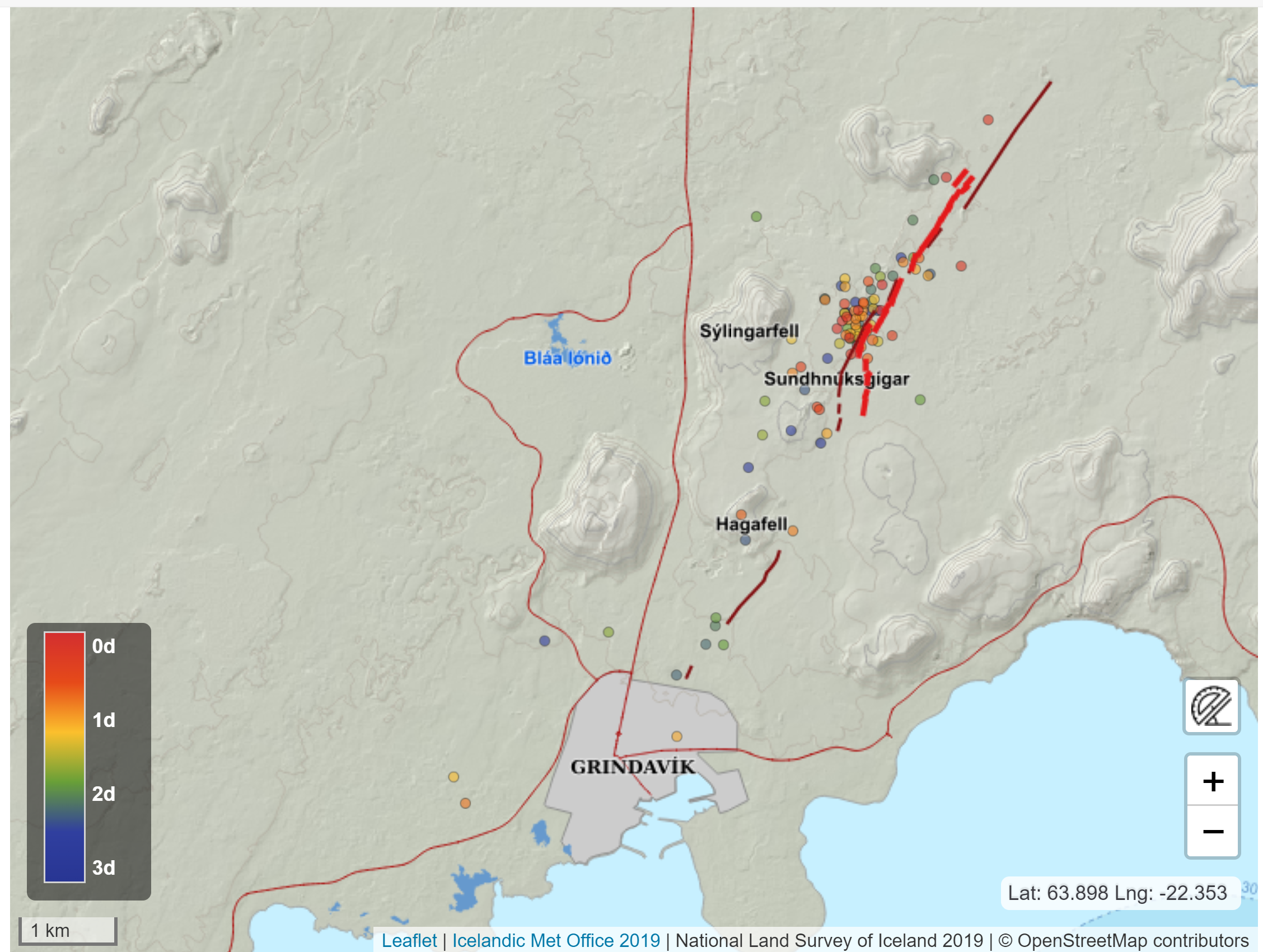
Therefore, the Iceland Meteorological Office has updated the hazard assessment for the unrest area. An increased likelihood of a volcanic eruption and related hazards affects the assessment. Hazard levels have been raised in several zones. Even though the color of Zone 4 – Grindavík - remains unchanged, the hazards there have increased due to the possibility of lava flows. The same goes for Zone 1 – Svartsengi.

No significant deformation within Grindavík has been detected by GNSS or satellite data. It is however likely that new faults will be revealed when snow melts or precipitation causes soil, which might be covering faults, to be washed away.
If an eruption occurs, scientists estimate that magma will most likely propagate from the reservoir beneath the Svartsengi-Þórbjörn region towards Sundhnúkur crater row, resulting in lava fountaining and lava flows in the area between Stóra-Skógfell and Hagafell. The primary signal of ascending magma is a sudden increase in seismic activity with many localized, small-magnitude earthquakes. Considering the previous volcanic eruptions in the area, an eruption could start with very little warning (less than 30 minutes), depending on where magma reaches the surface on the Sundhnúkur crater row.
Likely scenarios
Eruption between Sýlingarfell and Stóra-Skógfell - As occurred on Dec. 18, 2023, and Feb. 8, 2024.
- Precursor: Sudden, localized, and intense seismic activity with small magnitude earthquakes. Deformation over the magma dike (if a dike is intruded) and the Svartsengi magma reservoir
- Very short warning time (less than 30 minutes) because a new dike propagation may not be required for magma to reach the surface.
- Lava reaches Grindavík road in less than 4 hours.
Eruption by Hagafell – As occurred on Jan. 14, 2024.
- Precursor: Seismic activity with small magnitude earthquakes on the Sundhnúkur crater row, starting near Sýlingarfell and migrating south. Deformation over the magma dike and the Svartsengi magma reservoir
- Likely warning time is approximately 1-3 hours from the detection of the first earthquakes until the start of an eruption.
- Lava reaches the lava barriers around Grindavík within 1 hour.
- Magma intrusion, which reaches south of Hagafell, will likely cause significant fault movements in Grindavík
Eruption inside of the lava barriers around Grindavík
- Seismic activity with small magnitude earthquakes on the Sundhnúkur crater row, starting near Sýlingarfell and migrating south. Deformation over the magma dike and the Svartsengi magma reservoir
- Probable warning time is between approximately 1-5 hours from the detection of the first earthquakes until the start of an eruption.
- An eruptive fissure/s may open within Grindavík or the region just north of here (inside the barriers). Similar activity occurred on 14 Jan. when a volcanic fissure opened just inside the outer perimeter of the town approximately 4 hours after the onset of the eruption near Hagafell.
- Magma intrusion, which reaches south of Grindavík, will cause significant fault movements in Grindavík.
- CreatedTuesday, February 27, 2024
- Last modifiedThursday, February 29, 2024
SUBSCRIBE
Sign up for our weekly newsletter and World News Trust project updates.

World Desk Activities

cpj.org/resources-for-journalists-covering-protest…

cpj.org/2020/09/guide-to-legal-rights-in-the-u-s/

pressfreedomtracker.us/submit-incident/

drive.google.com/file/d/17XyVCVOTq59bvTEG_RZAQMgrF…

www.icfj.org/news/new-icfj-knight-fellows-work-sup…

U.S.Justice Department: "Radical Right vs. Radical Left: Terrorist Theory and Threat"
www.ojp.gov/ncjrs/virtual-library/abstracts/radica….
ijnet.org/en/story/tips-building-networks-reach-au…

trustingnews.org/how-trustworthy-is-your-newsroom-…

Latest Stories


Electronic Frontier Foundation
- EFF to Court: Electronic Ankle Monitoring Is Bad. Sharing That Data Is Even Worse. May 17, 2024
- EFF Urges Ninth Circuit to Hold Montana’s TikTok Ban Unconstitutional May 17, 2024
- Fair Use Still Protects Histories and Documentaries—Even Tiger King May 15, 2024
- The Cybertiger Strikes Again! EFF's 8th Annual Tech Trivia Night May 15, 2024
The Intercept
- The State Department Says Israel Isn’t Blocking Aid. Videos Show the Opposite. May 18, 2024
- Medical Workers Evacuated From Gaza, but 3 Americans Refuse to Leave May 17, 2024
- An Israeli Company Is Hawking Its Self-Launching Drone System to U.S. Police Departments May 17, 2024
- The Consumer Finance Protection Bureau Is Constitutional, After All May 16, 2024
