
Iceland Volcano: Increased Risk Of An Eruption In The Coming Days -- Iceland Met Office
Categories
Edited | All Content | Disasters | Earthquakes | Volcanos | Government | Science | North America | Europe | Atlantic Ocean | News | News -- WNT Selected
 Updated Hazard Map valid until Jan. 12, 2024
Model calculations indicate the intrusion beneath Svartsengi has accumulated a volume of magma similar to when the Dec. 18 eruption began
Information is updated regularly here and on X (Formerly known as Twitter).
Updated 9 January at 13:00 UTC
Seismic activity continues to exhibit a pattern similar to that of recent days. The earthquake activity remains relatively low, primarily centered between Hagafell and Stóra Skógfell, where the center of the intrusion is situated. Additionally, there is ongoing seismic activity in Fagradalsfjall, persisting since Dec. 18.
Land uplift is still being measured in the Svartsengi area, exhibiting a relatively stable trend since the eruption on Dec. 18. The accompanying image, marked with red dots representing data from the GPS station SENG in Svartsengi, illustrates this trajectory The recent rate of uplift is approximately 5 mm per day, resulting in a current elevation that is about 5 cm higher than before the eruptions on Nov. 10 and Dec. 18 last year.
Calculations from models relying on deformation measurements (GPS and satellite images) indicate that the amount of magma accumulated in the reservoir beneath Svartsengi has reached a level comparable to the volume that led to the formation of the magma conduit and the subsequent eruption on Dec. 18 last year. This suggests that there is an increased risk of an eruption in the coming days.
The Icelandic Meteorological Office issued an updated hazard map on Jan. 5, and it will be reassessed on Jan. 12.
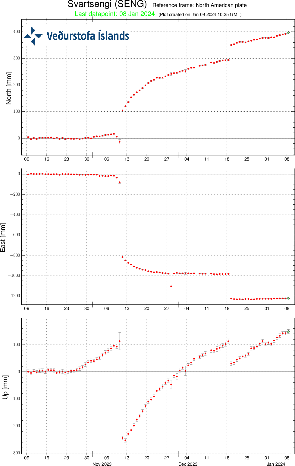 Relative measurements from the GPS station SENG in Svartsengi from the beginning of October 2023 to present, displaying north, east, and vertical components (top, middle, bottom). The bottom curve shows land uplift in millimeters, with today's measurement indicated by a green dot.
- CreatedTuesday, January 09, 2024
- Last modifiedMonday, February 05, 2024
SUBSCRIBE
Sign up for our weekly newsletter and World News Trust project updates.

World Desk Activities

cpj.org/resources-for-journalists-covering-protest…

cpj.org/2020/09/guide-to-legal-rights-in-the-u-s/

pressfreedomtracker.us/submit-incident/

drive.google.com/file/d/17XyVCVOTq59bvTEG_RZAQMgrF…

www.icfj.org/news/new-icfj-knight-fellows-work-sup…

U.S.Justice Department: "Radical Right vs. Radical Left: Terrorist Theory and Threat"
www.ojp.gov/ncjrs/virtual-library/abstracts/radica….
ijnet.org/en/story/tips-building-networks-reach-au…

trustingnews.org/how-trustworthy-is-your-newsroom-…

Latest Stories


Electronic Frontier Foundation
- EFF to Court: Electronic Ankle Monitoring Is Bad. Sharing That Data Is Even Worse. May 17, 2024
- EFF Urges Ninth Circuit to Hold Montana’s TikTok Ban Unconstitutional May 17, 2024
- Fair Use Still Protects Histories and Documentaries—Even Tiger King May 15, 2024
- The Cybertiger Strikes Again! EFF's 8th Annual Tech Trivia Night May 15, 2024
The Intercept
- The State Department Says Israel Isn’t Blocking Aid. Videos Show the Opposite. May 18, 2024
- Medical Workers Evacuated From Gaza, but 3 Americans Refuse to Leave May 17, 2024
- An Israeli Company Is Hawking Its Self-Launching Drone System to U.S. Police Departments May 17, 2024
- The Consumer Finance Protection Bureau Is Constitutional, After All May 16, 2024
