
Iceland Volcano: Steady Eruption Activity -- Iceland Met Office
Categories
Edited | All Content | Disasters | Earthquakes | Volcanos | Government | Health | Science | Europe | Atlantic Ocean | News | News -- WNT Original
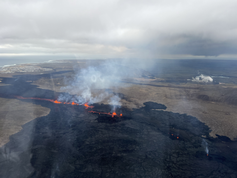 Overview photo of the eruption centers taken in flight March 20, 2024. Visible are all the active craters and a lava flow from them to the south. In the background on the left, you can see Grindavíkurbær, and on the right, you can see Svartsengi (Photo: Birgir V. Óskarsson - Natural Science Foundation)
Continued hazard due to volcanic gas
Updated 27. March at 14:00 UTC
- High levels of SO2 (Sulfur Dioxide) were measured over the weekend. Gas dispersion forecast can be followed here .
- This concentration of SO2 is considered very unhealthy. It is important to pay close attention to developments in air quality.
- The volcanic eruption has been stable since Monday, 25 March.
The volcanic eruption has been stable since Monday, 25 March. Eruption tremor has remained consistent since then, as has the activity in the three craters. Lava continues to flow southward from the craters mostly atop the lava field formed during the first days of the eruption. The following image shows the extension of the lava field as extrapolated from satellite images (ICEYE). The latest acquisition was on 26 March and it shows the widening of lava field towards the west, south of Hagafell, as well as further lava advancement towards the east and the south of the active vents.
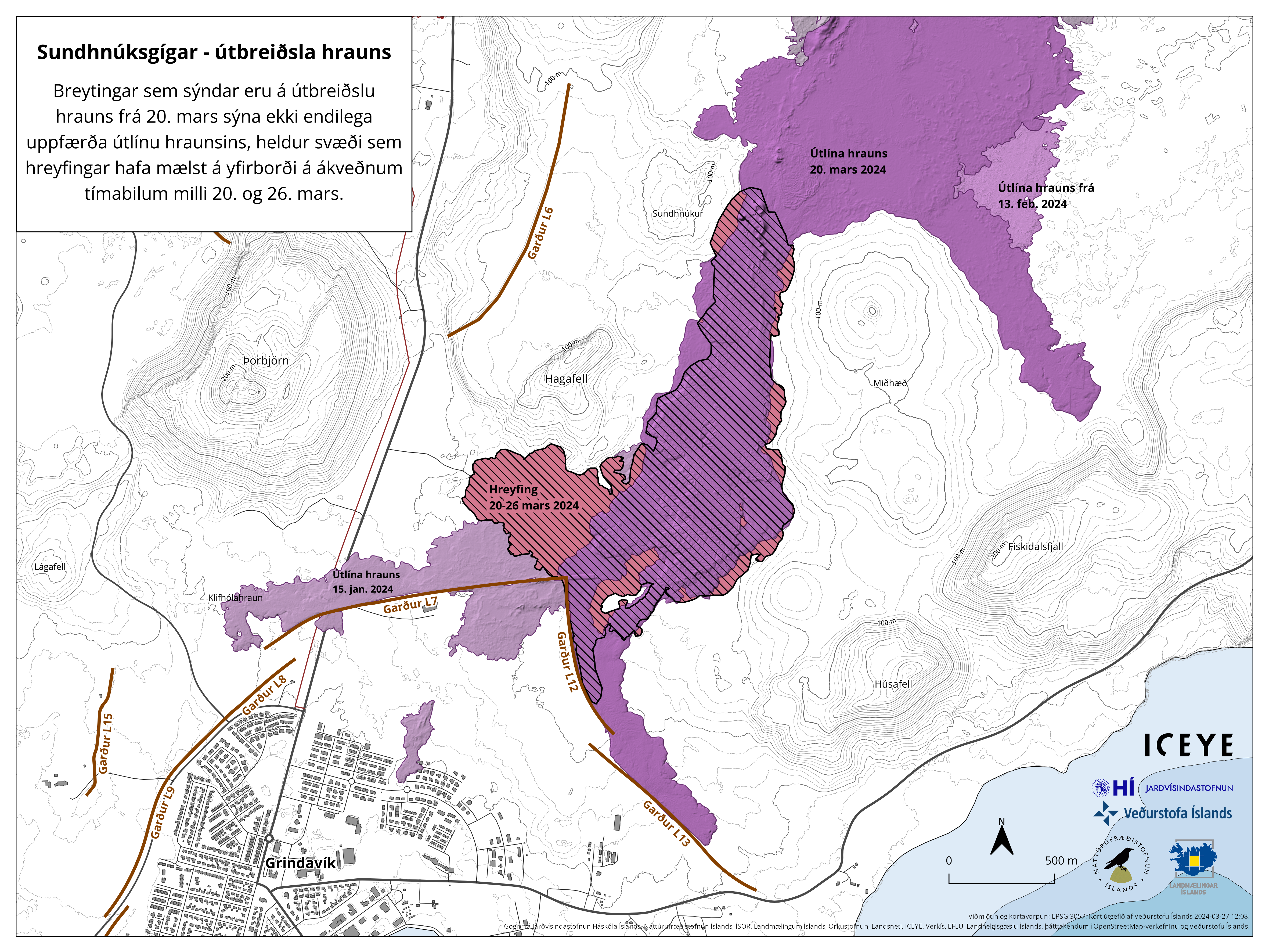 Striped areas indicate regions where changes occurred in the lava field between March 20 and 26. The red-striped part of the area signifies area where lava had not flowed previously in this eruption. Light purple areas denote areas where lava flowed from eruptions in February and January. (Click image to enlarge)
Uplift continues in Svartsengi but at a slower rate than before previous eruptions or dike intrusions in recent months. This suggests that magma is still accumulating beneath Svartsengi despite ongoing eruption. Little to no seismic activity has been detected in the area.
High levels of SO2 measured past few days
Since Friday 22 March, two additional stations to monitor the concentrations of SO2 at the ground have been installed. VÍ, in collaboration with Almannavarnir, located them at Blue Lagoon and in the harbor area in Grindavík. Both stations are streaming data to the UST website, loftgæði.is.
Early yesterday morning, at around 03:00, the station in BL revealed levels of SO2 up to 7000 microgram/m3, and this morning at around 04:00 the station in Grindavík (Nesvegur) measured concentrations up to 9000 micrograms/m3. Such concentrations are considered óholl and people are recommended to follow the instructions provided by UST and Embætti landlæknis (link). On 26 March, the station in Hafnir also showed high concentrations of SO2 up to about 2000 microgarm/m3 around midday. The amount of SO2 released by the eruption and the meteorology in the area are still creating the conditions for severe gas pollution in the peninsula.
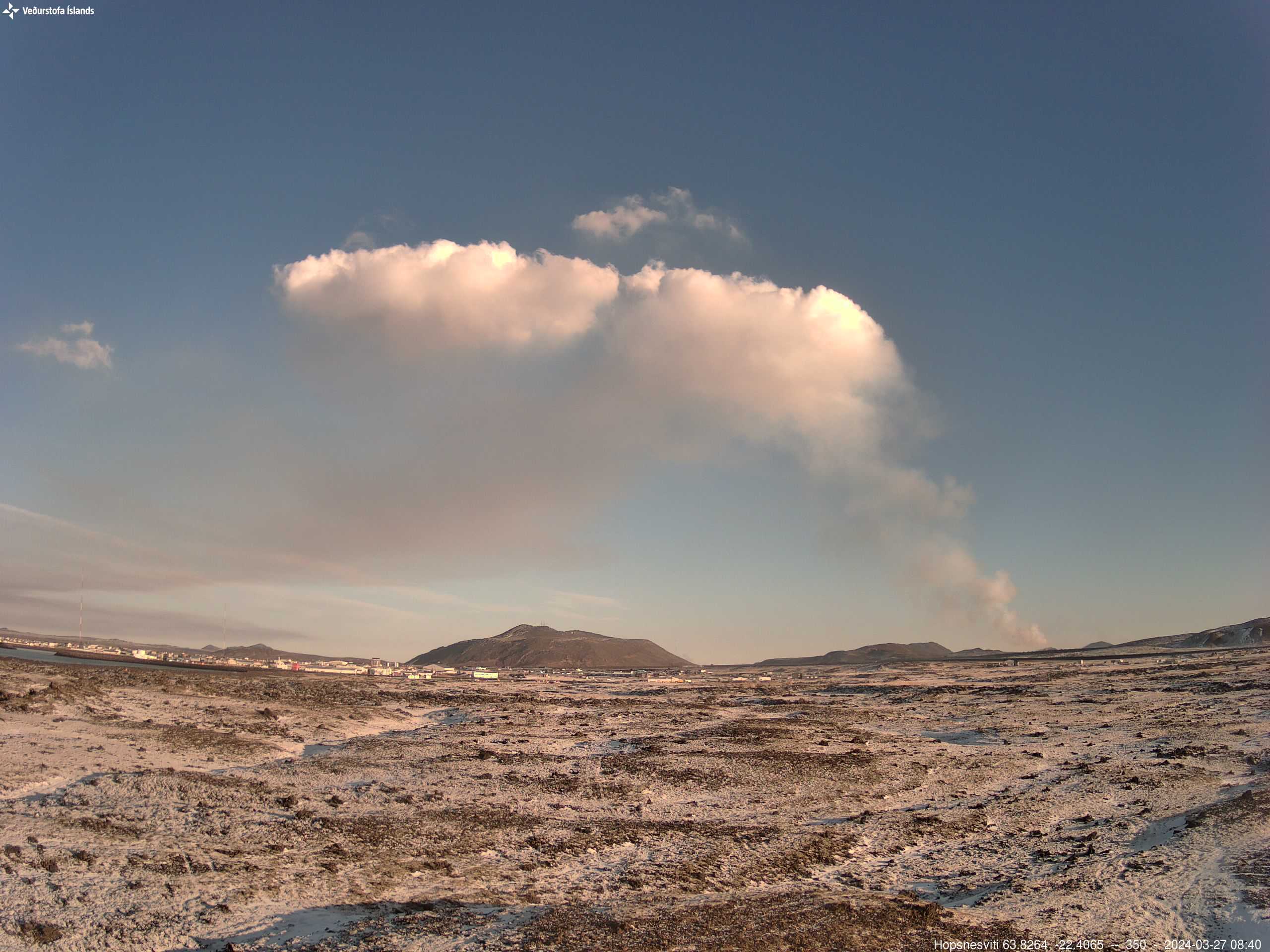 Photo 27 March from IMO's webcam located at Hópsnes SE of Grindavík. In the center of the photo is Mt. Þorbjörn and the eruption site east of it where the gas plume rises and moves to the west because of easterly winds.
- CreatedThursday, March 28, 2024
- Last modifiedSunday, April 07, 2024
SUBSCRIBE
Sign up for our weekly newsletter and World News Trust project updates.

World Desk Activities

cpj.org/resources-for-journalists-covering-protest…

cpj.org/2020/09/guide-to-legal-rights-in-the-u-s/

pressfreedomtracker.us/submit-incident/

drive.google.com/file/d/17XyVCVOTq59bvTEG_RZAQMgrF…

www.icfj.org/news/new-icfj-knight-fellows-work-sup…

U.S.Justice Department: "Radical Right vs. Radical Left: Terrorist Theory and Threat"
www.ojp.gov/ncjrs/virtual-library/abstracts/radica….
ijnet.org/en/story/tips-building-networks-reach-au…

trustingnews.org/how-trustworthy-is-your-newsroom-…

Latest Stories


Electronic Frontier Foundation
- EFF to Court: Electronic Ankle Monitoring Is Bad. Sharing That Data Is Even Worse. May 17, 2024
- EFF Urges Ninth Circuit to Hold Montana’s TikTok Ban Unconstitutional May 17, 2024
- Fair Use Still Protects Histories and Documentaries—Even Tiger King May 15, 2024
- The Cybertiger Strikes Again! EFF's 8th Annual Tech Trivia Night May 15, 2024
The Intercept
- The State Department Says Israel Isn’t Blocking Aid. Videos Show the Opposite. May 18, 2024
- Medical Workers Evacuated From Gaza, but 3 Americans Refuse to Leave May 17, 2024
- An Israeli Company Is Hawking Its Self-Launching Drone System to U.S. Police Departments May 17, 2024
- The Consumer Finance Protection Bureau Is Constitutional, After All May 16, 2024
