
Iceland Volcano: Two Craters Still Active -- Iceland Met Office
Categories
Edited | All Content | Disasters | Earthquakes | Volcanos | Government | Science | Europe | Atlantic Ocean | News | News -- WNT Selected
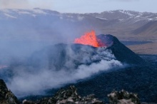
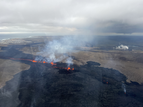 Overview photo of the eruption centers taken in flight March 20, 2024. Visible are all the active craters and a lava flow from them to the south. In the background on the left, you can see Grindavíkurbær, and on the right, you can see Svartsengi (Photo: Birgir V. Óskarsson - Natural Science Foundation)
High SO2 levels continue to be detected occasionally around the eruption and in municipalities in the Reykjanes peninsula
Updated 4. April at 17:00 UTC
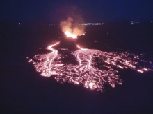
The eruption at the Sundhnúkur crater row continues and two craters are still active as in recent days. The northern crater is larger and most of the lava flow seems to be erupted from it, as can be seen in the image below which was taken last night, 3 April. Lava continues to flow south from the craters on top of the lava field formed in the first few days of this eruption. Last night there were no clear signs of lava flow progressing alongside the lava barriers north of Grindavík, Southcoast road or Melhólsnáma mine.
 Aerial image from a drone flight operated by Civil Protection on 3 April. The image shows the two craters and the lava flowing from them towards the south.
An interferogram covering the period 18 March - 3 April shows that land has risen about 3 cm in Svartsengi during that time. This is considerably slower deformation that was measured before the eruptions and dike propagations which have occurred in the last months. Data from GPS measurements during the same period suggests that the rate of the land uplift has varied, but it is difficult to estimate day-to-day deformation based on this data. Considering the GPS data for the same period as the interferogram (18March – 3 April), the two datasets are consistent. Land uplift is detected in Svartsengi during the eruption, which has not been seen in the events that have occurred previously on the Sundhnúkur crater row. This indicates that the system is open, and magma continues to flow from a considerable depth below Svartsengi to the surface in the Sundhnúkur crater row.
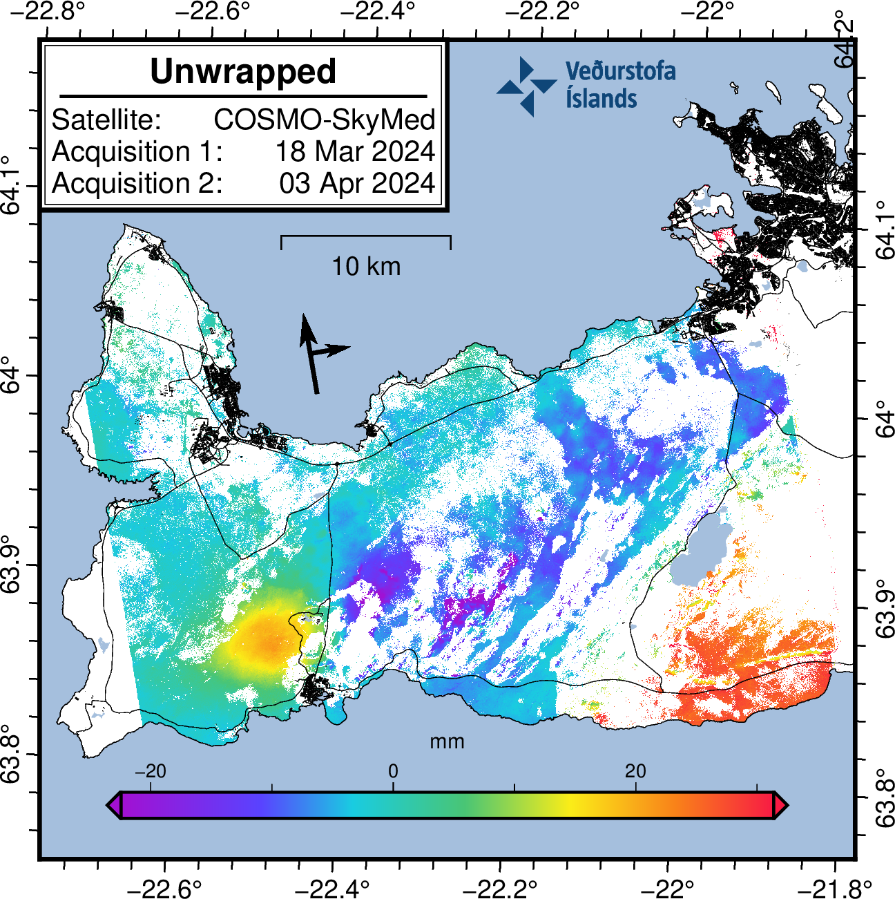 Interferogram (InSAR) showing deformation from 18 March – 3 April. Yellow and orange colors show areas around Svartsengi where land uplift is detected.
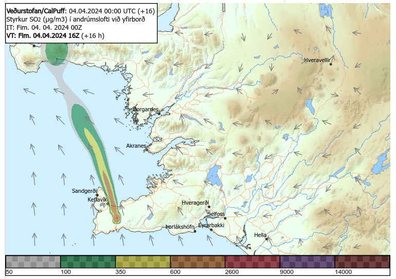
Gas measurements carried out 2 April, estimate that approx. 37-41 kg/s of SO2 is emitted from the craters. Temporary high sulfur dioxide levels continue to be measured around the eruption site and in municipalities in the Reykjanes peninsula. Gas from the eruption is likely to cause pollution in the Reykjanes peninsula and we advise people in the area to monitor air quality at loftgaedi.is and familiarize themselves with the response to air pollution from volcanic eruptions.
The weather forecast is southeast and southerly winds of 8-13 m/s at the eruption site, causing gas to be dispersed to the northwest and north, meaning gas could be detected in Vogar, Reykjanesbær and Suðurnesjabær. Easterly winds 5-10 m/s Friday, causing gas dispersion towards the west, for example to Svartsengi. Northeasterly winds, 5-10 m/s late tomorrow causing gas pollution in the southwest and possibly in Grindavík.
Gas distribution forecast is here.
 Click the image to enlarge
Hazard assessment published on 2 April remains unchanged and is valid until 9 April barring any developments.
Updated 2. April at 17:30 UTC
The eruption continues and two craters are now active. Inflation hasn‘t been detected in the last few days.
Lately, vegetation fires have started around the lava field, and is an ongoing risk while the weather is dry.
Gas pollution is dispersed to the southwest and later to the west and is likely to be detected occasionally in Grindavík and possibly in Hafnir. Gas distribution forecast and air quality can be monitored.
Lava margins have reached considerable heights and can be unstable.
Hazard assessment unchanged.
The eruption at the Sundhnúkur crater row continues and two craters are now active. The third crater, which was much smaller than the other two, was extinguished at Easter. Volcanic tremor remains stable.
Inflation in Svartsengi has not been detected in recent days, indicating that less magma accumulates in the magma reservoir beneath Svartsengi, and flows instead towards the craters where it erupts. A balance may be reached between the influx of magma into the Svartsengi reservoir and the eruptive craters, but geochemical surveys might confirm this in the future.
Experts from the National Land Survey of Iceland have processed satellite data from 27 March showing that the lava field was then 5.99 km2 and the volume of lava since the beginning of the eruption was 25.7 ± 1.9 million m3. The average extrusive rate of lava from the craters was estimated at 7.8 ± 0.7 m3/s, which is very comparable to the extrusion rate during the first phase of the Geldingadalir eruption in 2021. The aim is to take aerial photographs of the area in the coming days to get updated extrusion rates since 27 March, which will give further insights into the development of the eruptive activity. The following map shows the lava flow field and its thickness as it was on 27 March.
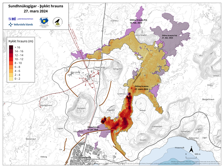 Map showing the flow field and thickness of the lava formed during the ongoing eruption. Purple layers show lavas that have formed in the area since December 2023.
Vegetation fires around the lava field
Lately, vegetation fires have started around the lava field, and are an ongoing risk while the weather is dry.
Lava margins have reached considerable heights and can be unstable, sudden and rapid lava outbursts can occur if new lobes of lava break out from the edge of a lava margin.
In recent days, high levels of hydrogen sulfide have occasionally been detected in Grindavík. The weather forecast today (Tuesday) is northeasterly and later easterly winds 5-13 m/s at the eruption site. Gas pollution is therefore dispersed to the southwest and later to the west, and is likely to be detected occasionally in Grindavík and possibly in Hafnir. Easterly and southeasterly winds 3-10 m/s tomorrow (Wednesday) causing gas pollution to travel to the west and northwest, and thus could be detected in many parts of the western Reykjanes area, including Reykjanesbær. Gas distribution forecast is here.
Hazard assessment unchanged
The hazard assessment has been updated and is valid from 15:00 today until 9 April, barring any significant developments. There are no changes to the hazard assessment and the hazard from gas pollution continues to be assessed high in all areas except at the Sundhnúkur crater row area (zone 3) where it is assessed as very high. The hazard in zone 4 (Grindavík) and zone 6 continues to be assessed as high due to sinkholes, fault movements, lava flow and gas pollution.

- CreatedThursday, April 04, 2024
- Last modifiedFriday, April 12, 2024
World Desk Activities

cpj.org/resources-for-journalists-covering-protest…

cpj.org/2020/09/guide-to-legal-rights-in-the-u-s/

pressfreedomtracker.us/submit-incident/

drive.google.com/file/d/17XyVCVOTq59bvTEG_RZAQMgrF…

www.icfj.org/news/new-icfj-knight-fellows-work-sup…

U.S.Justice Department: "Radical Right vs. Radical Left: Terrorist Theory and Threat"
www.ojp.gov/ncjrs/virtual-library/abstracts/radica….
ijnet.org/en/story/tips-building-networks-reach-au…

trustingnews.org/how-trustworthy-is-your-newsroom-…

Latest Stories


Electronic Frontier Foundation
The Intercept
- How much money did the NYPD waste quashing student protests? We tallied it up. May 07, 2024
- After Raids, NYPD Denied Student Protesters Water and Food in Jail May 06, 2024
- They Exposed an Israeli Spyware Firm. Now the Company Is Badgering Them in Court. May 06, 2024
- In No Labels Call, Josh Gottheimer, Mike Lawler, and University Trustees Agree: FBI Should Investigate Campus Protests May 04, 2024
VTDigger
- Final Reading: Lawmakers send safe injection site pilot legislation to Gov. Phil Scott May 07, 2024
- 3 of the session’s largest climate bills face opposition from Phil Scott administration May 07, 2024
- A coffee product’s ‘active ingredient’ leads to guilty plea in fraud case May 07, 2024
- In compromise, budget panel agrees to new limits on motel housing program May 07, 2024
