
Iceland Volcano: Vigor Of Eruption Decreases Significantly -- Iceland Met Office
Categories
Edited | All Content | Disasters | Earthquakes | Volcanos | Government | Science | Europe | Atlantic Ocean | News | News -- WNT Original
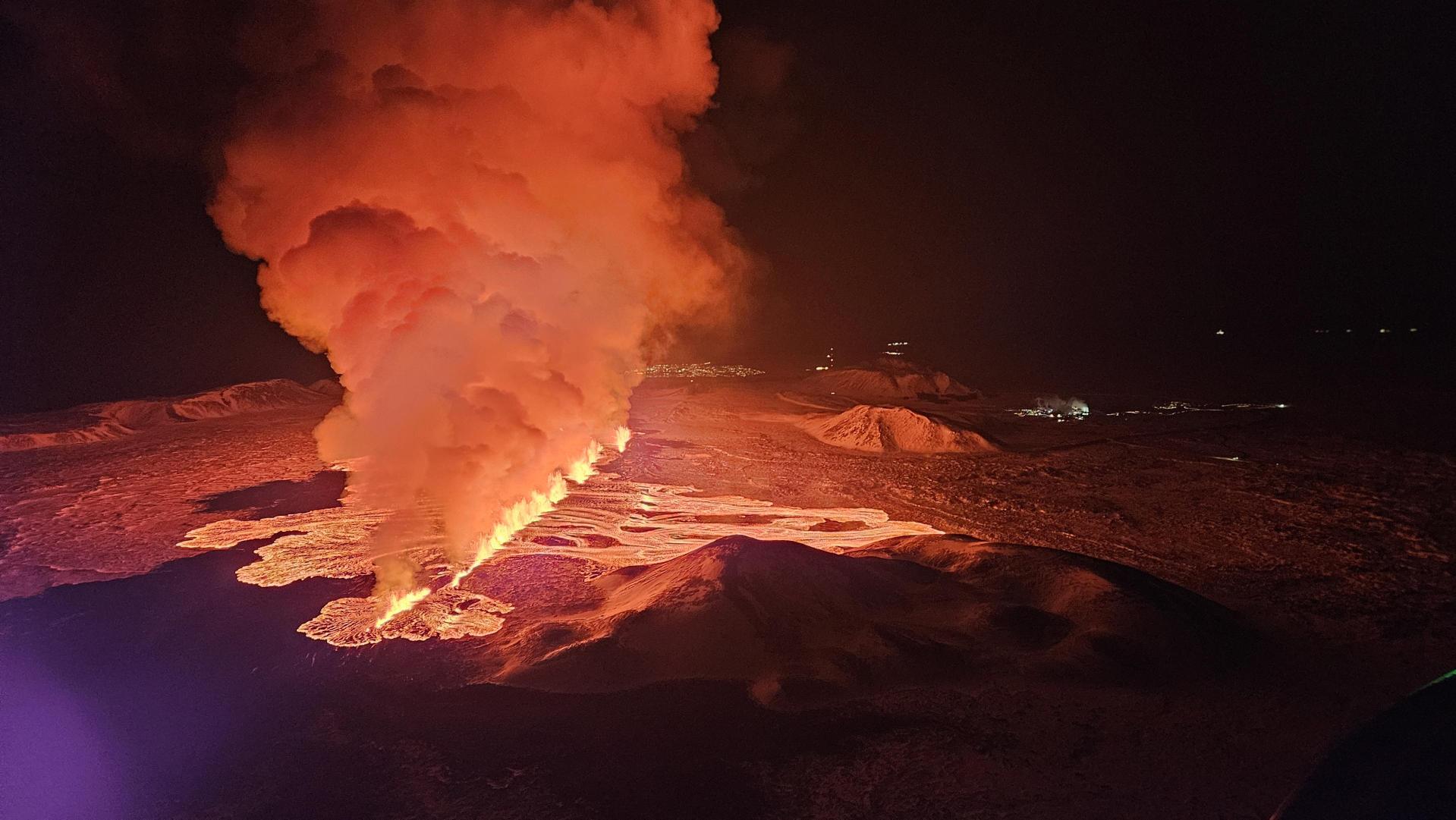 Image from the Icelandic Coast Guard's surveillance flight. Mt. Stóra-Skógfell in the foreground and the lights at the Svartsengi power station to the right. (Photo: Björn Oddsson).
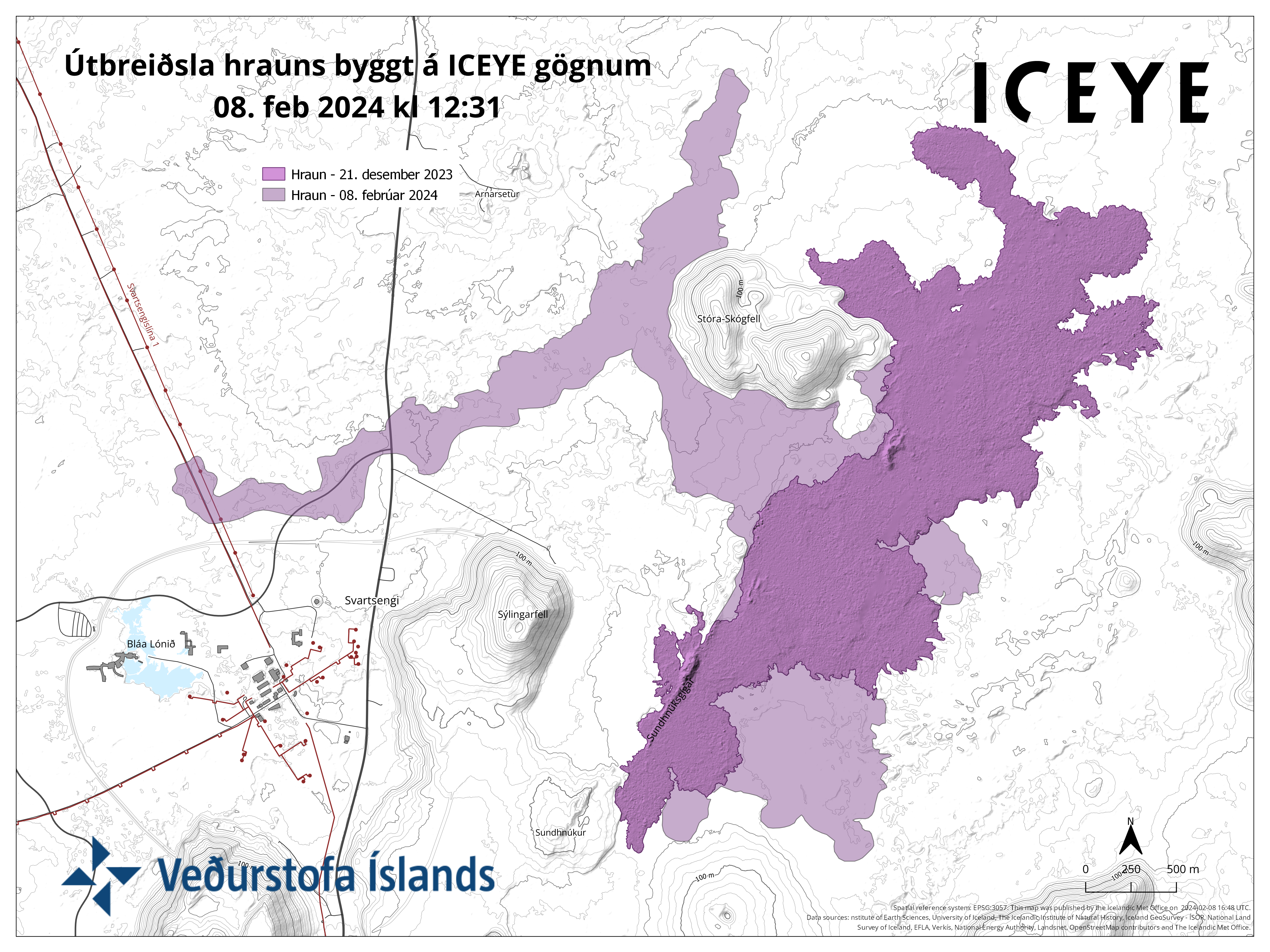
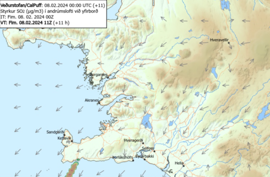
Satellite image shows lava flowed furthest about 4.5 km to the west of the eruptive site
Information is updated regularly here and on X (Formerly known as Twitter).
Updated 8. February at 17:15 UTC
The vigor of the eruption continues to decrease. The eruptive activity is currently at two or three locations on the eruptive fissure. The explosive activity that began between 13:00 and 14:00 UTC is now mostly over, but minor convective clouds rise from some parts of the fissure.
Synchronously with the decreasing vigor of the eruption, the deformation signals detected at the dyke area diminished, indicating that magma is no longer ascending under as much pressure as before. Soon after the onset of the eruption, seismic activity decreased significantly and has remained minor thus far. About 20 small earthquakes have been detected over the dyke since 08:00 this morning.
The map shows outlines of the lava flow as it was seen on a satellite image taken at 12:31 today. The satellite image shows that lava flowed furthest about 4.5 km to the west from the eruptive site. For comparison, the lava flow field that formed in the eruption on 18 Dec. 2023 is also shown on the map. Today‘s lava flows partly over the lava flow formed in December 2023.
 (Click on the map to make it larger)
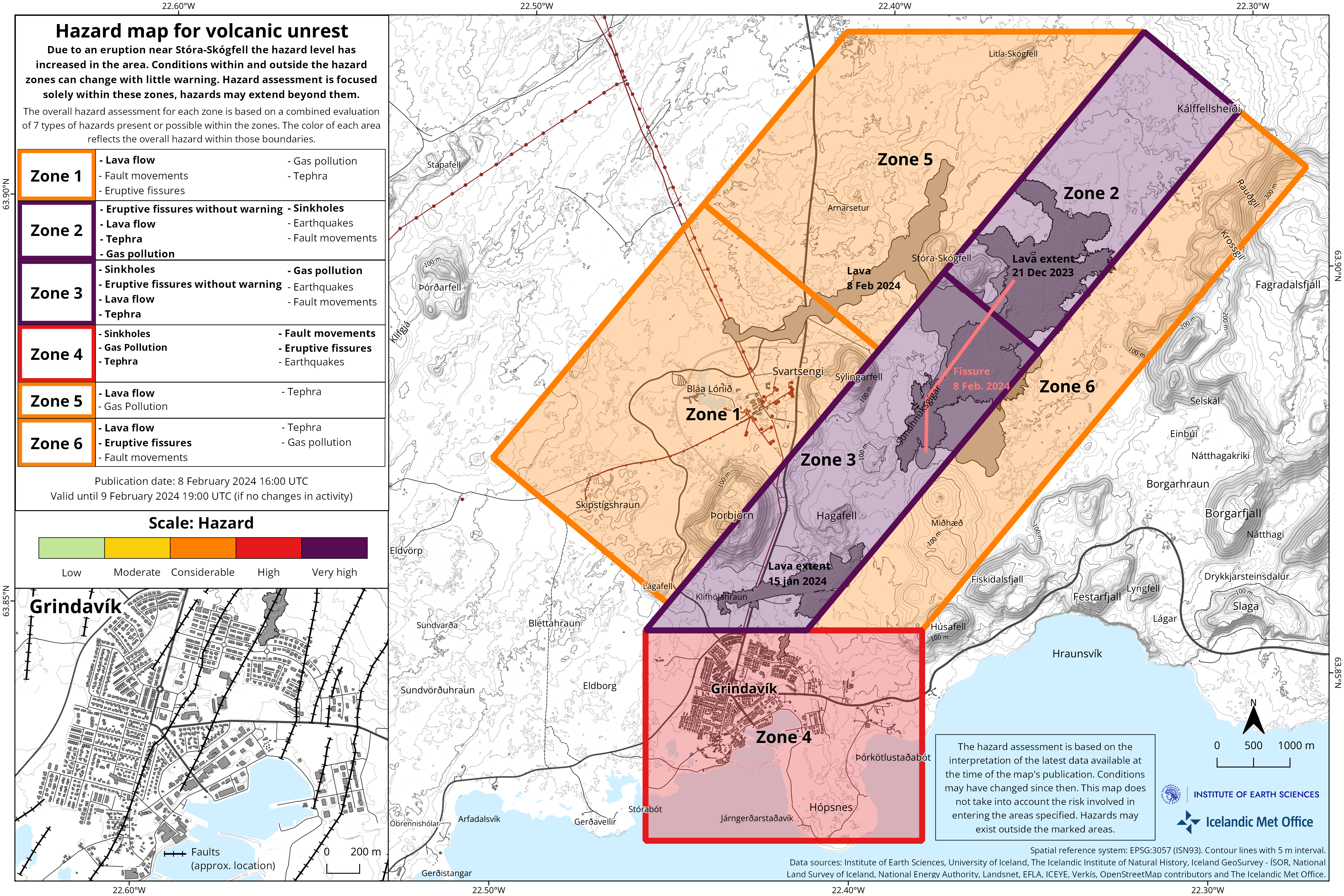 The Iceland Meteorological Office has updated the hazard assessment map considering the process of the eruptive activity. Changes have been made to the hazard assessment for some hazards within zones. However, these changes do not influence the overall hazard assessment for the zones. The new lava flow field has also been added to the map. The hazard assessment map is valid until 19:00 tomorrow, Friday 9th of February 2024, unless development in activity calls for a re-evaluation. (Click on the map to make it larger)
Updated 8. February at 14:25 UTC
The vigor of the eruption is decreasing. The activity is now mainly on 3 locations on the eruptive fissure which opened this morning. This is not unlike the process observed in the eruption on 18 Dec. 2023 when the activity was confined to a few craters a few hours after the onset of the eruption.
A conspicuous, dark plume rises from one part of the eruptive fissure. This is likely due to magma interaction with groundwater which results in a slight explosive activity where a white plume of steam mixes with a dark volcanic plume.
It seems that tephra does not travel far from the eruptive fissure at the moment. The volcanic plume is dispersed towards the southwest.
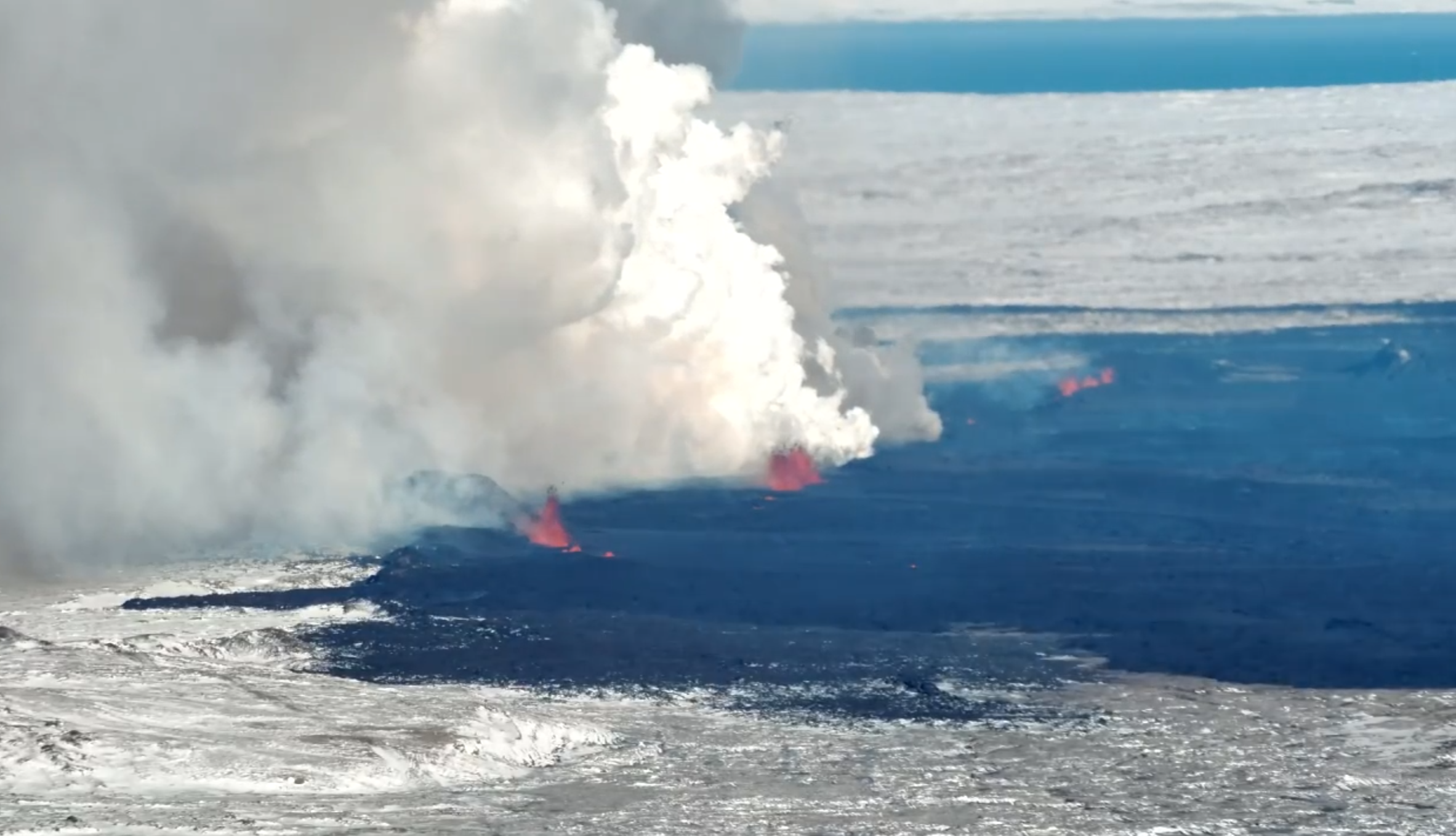 Photo taken towards the northwest. (Photo: Special Unit of the National Police Commissioner)
Updated 8. February at 12:20 UTC
Geodetic data suggest that deformation has decreased significantly in the dyke area. Therefore, the probability of new eruptive fissure openings has decreased.
The Iceland Met Office has received notifications of tephra fall in Grindavík.
 Tephra is a frothy and vesicular material that forms when splashes of lava cool quickly in the air in the lava fountaining activity. This process took place when an eruptive fissure opened this morning (8th of February 2024). Due to the tephras‘ vesicularity and lightness, it can be transported far within the volcanic plume with wind. It falls in Grindavík now, 3-5 km from the source of formation due to the height of the lava fountains, northeasterly wind direction, thermal upwelling from the lava, and low air temperature.
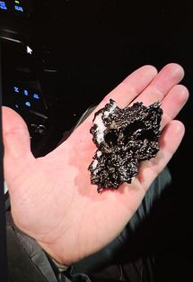
Tephra is a synonym for all airborne, solid, eruptive materials, regardless of size an type. Tephra formation is well known in Iceland, such as in the explosive eruptions in Grímsvötn 2011 and 2004, and Eyjafjallajökull 2010. In explosive eruptions, the lava is more fragmented in the air and produces finer-grained tephra but tephra can also be produced in effusive eruptions such as is now ongoing on the Reykjanes peninsula. In effusive eruptions, the majority of tephra is deposited close to the vent and thus is not well detectable outside of the lava flow field. In May 2021, when lava fountaining was most active in the eruption in Fagradalsfjall, large pieces of tephra (up to 10 cm in diameter) fell at about 1 km distance from the eruptive source.
Tephra is sharp as glass and thus should be carefully handled. Windscreen wipers should not be used to remove tephra from vehicles as it will scratch the glass. Tephra should rather be blown or washed off with water of windows and similar surfaces.
Gas dispersion
 The weather forecast for gas dispersion from the volcanic site is north-easterly winds, 4-8 m/s today (Thursday), thus gas is dispersed towards southwest. Decreasing wind speed tonight which can cause gas concentrations to build up at the volcanic site. Easterly and south-easterly winds, 5-10 m/s after noon tomorrow (Friday), causing gas to be dispersed to the west and northwest, towards Keflavík.
Updated 8. February at 11:40 UTC
The Icelandic Met Office has updated the hazard map for the area. The hazard level has increased in all areas due to the eruption.
 The Iceland Meteorological Office has updated the hazard assessment map considering the process of the eruptive activity. Changes have been made to the hazard assessment for some hazards within zones. However, these changes do not influence the overall hazard assessment for the zones. The new lava flow field has also been added to the map. The hazard assessment map is valid until 19:00 tomorrow, Friday 9th of February 2024, unless development in activity calls for a re-evaluation. (Click on the map to make it larger)
Updated 8 February at 7:50 UTC
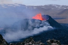
At 5:30 this morning an intense seismic activity started northeast of Mt. Sýlingarfell. Around 30 minutes later, a volcanic eruption started at the site.
The eruptive fissure lengthened toward both the north and south during the first minutes.
The first images from the Icelandic Coast Guard's surveillance flight suggest that the eruption is taking place at a similar location as the eruption on 18 Dec. 2023. The eruptive fissure is approximately 3 km long, from Mt. Sundhnúkur in the south and stretches towards the eastern part of Mt. Stóra-Skógfell. Lava flows mostly toward the west at the moment and the flow seems to be slightly less than at the start of the 18 Dec. eruption.
The lava fountains reach about 50-80 m height and the volcanic plume rises about 3 km above the eruptive fissure.
Image from the Icelandic Coast Guard's surveillance flight. Mt. Stóra-Skógfell in the foreground and the lights at the Svartsengi power station to the right. (Photo: Björn Oddsson).
- CreatedThursday, February 08, 2024
- Last modifiedFriday, February 09, 2024
SUBSCRIBE
Sign up for our weekly newsletter and World News Trust project updates.

World Desk Activities

cpj.org/resources-for-journalists-covering-protest…

cpj.org/2020/09/guide-to-legal-rights-in-the-u-s/

pressfreedomtracker.us/submit-incident/

drive.google.com/file/d/17XyVCVOTq59bvTEG_RZAQMgrF…

www.icfj.org/news/new-icfj-knight-fellows-work-sup…

U.S.Justice Department: "Radical Right vs. Radical Left: Terrorist Theory and Threat"
www.ojp.gov/ncjrs/virtual-library/abstracts/radica….
ijnet.org/en/story/tips-building-networks-reach-au…

trustingnews.org/how-trustworthy-is-your-newsroom-…

Latest Stories


Electronic Frontier Foundation
- EFF to Court: Electronic Ankle Monitoring Is Bad. Sharing That Data Is Even Worse. May 17, 2024
- EFF Urges Ninth Circuit to Hold Montana’s TikTok Ban Unconstitutional May 17, 2024
- Fair Use Still Protects Histories and Documentaries—Even Tiger King May 15, 2024
- The Cybertiger Strikes Again! EFF's 8th Annual Tech Trivia Night May 15, 2024
The Intercept
- The State Department Says Israel Isn’t Blocking Aid. Videos Show the Opposite. May 18, 2024
- Medical Workers Evacuated From Gaza, but 3 Americans Refuse to Leave May 17, 2024
- An Israeli Company Is Hawking Its Self-Launching Drone System to U.S. Police Departments May 17, 2024
- The Consumer Finance Protection Bureau Is Constitutional, After All May 16, 2024
