
Iceland Volcano: Increased Probability Of A New Eruption -- Iceland Met Office
Categories
Edited | Front Page Stories | All Content | Disasters | Environment | Earthquakes | Volcanos | Government | Science | North America | Europe | Atlantic Ocean | News -- WNT Original
Information is updated regularly here and on X (Formerly known as Twitter).
Updated 29 December at 15:15 UTC
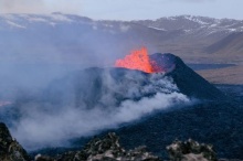
The ground continues to inflate at Svartsengi. At the GPS station Svartsengi (SENG), the land has now reached a similar height as measured just before the eruption on 18 December. The rate of uplift since 18 December has remained constant, which is different from the situation before the last eruption, where uplift slowed in the days before the eruption. However, it is difficult to assert that the uplift will slow down before the next eruption, though this has been the case in eruptions on the Reykjanes Peninsula in recent years, and it was also noted during the Krafla Fires. Uncertainty remains about how much magma pressure needs to build up before magma starts moving towards the surface.
The current uplift is not accompanied by as much seismic activity as before. The reason for this is that significant stress in the area was released during the events on 10 November and 18 December. Therefore, considerably more magma needs to accumulate before seismic activity increases from its current level. Before the last eruption, there were several earthquakes over magnitude 3 and one over magnitude 4. Similar seismic activity can be expected in connection with the next magma intrusion.
As magma accumulation continues under Svartsengi, the likelihood of another magma intrusion and an eruption increases with each passing day. It is most likely that the next eruption will occur in the Sundhnúkur, between Stóra-Skógfell and Hagafell. It is important to note that magma intrusions do not always lead to an eruption, as shown by the activity at Fagradalsfjall and in the Krafla Fires.
The Icelandic Meteorological Office has issued an updated hazard map, based on the joint interpretation of data at a status meeting held today, 29 December. The overall assessment of hazard levels within the areas remains unchanged from the last update. However, changes have been made to the list of potential hazards within area 4, Grindavík, where risks due to possible lava flow and gas pollution have been added. The changes are due to increased chances of an eruption north of Grindavík. This hazard map will be reviewed on 5 January 2024.
In the meantime, IMO continues to monitor the area and any changes will be communicated directly to civil protection via the usual communication channels.

- CreatedFriday, December 29, 2023
- Last modifiedMonday, May 20, 2024
SUBSCRIBE
Sign up for our weekly newsletter and World News Trust project updates.

World Desk Activities

cpj.org/resources-for-journalists-covering-protest…

cpj.org/2020/09/guide-to-legal-rights-in-the-u-s/

pressfreedomtracker.us/submit-incident/

drive.google.com/file/d/17XyVCVOTq59bvTEG_RZAQMgrF…

www.icfj.org/news/new-icfj-knight-fellows-work-sup…

U.S.Justice Department: "Radical Right vs. Radical Left: Terrorist Theory and Threat"
www.ojp.gov/ncjrs/virtual-library/abstracts/radica….
ijnet.org/en/story/tips-building-networks-reach-au…

trustingnews.org/how-trustworthy-is-your-newsroom-…

Latest Stories


Electronic Frontier Foundation
- EFF to Court: Electronic Ankle Monitoring Is Bad. Sharing That Data Is Even Worse. May 17, 2024
- EFF Urges Ninth Circuit to Hold Montana’s TikTok Ban Unconstitutional May 17, 2024
- Fair Use Still Protects Histories and Documentaries—Even Tiger King May 15, 2024
- The Cybertiger Strikes Again! EFF's 8th Annual Tech Trivia Night May 15, 2024
The Intercept
- The State Department Says Israel Isn’t Blocking Aid. Videos Show the Opposite. May 18, 2024
- Medical Workers Evacuated From Gaza, but 3 Americans Refuse to Leave May 17, 2024
- An Israeli Company Is Hawking Its Self-Launching Drone System to U.S. Police Departments May 17, 2024
- The Consumer Finance Protection Bureau Is Constitutional, After All May 16, 2024
