
Iceland Volcano: Updated Hazard Assessment -- Iceland Met Office
Categories
Edited | All Content | Disasters | Earthquakes | Volcanos | Government | Science | Europe | Atlantic Ocean | News | News -- WNT Selected
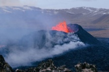
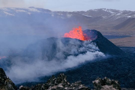 Volcano eruption at Sundhnúkur. Photo taken 10. April 2024 by Jón Bjarni Friðriksson/IMO.
The eruption at Sundhnúkur crater row has been ongoing for a month.
Updated April 16 at 18:00 UTC
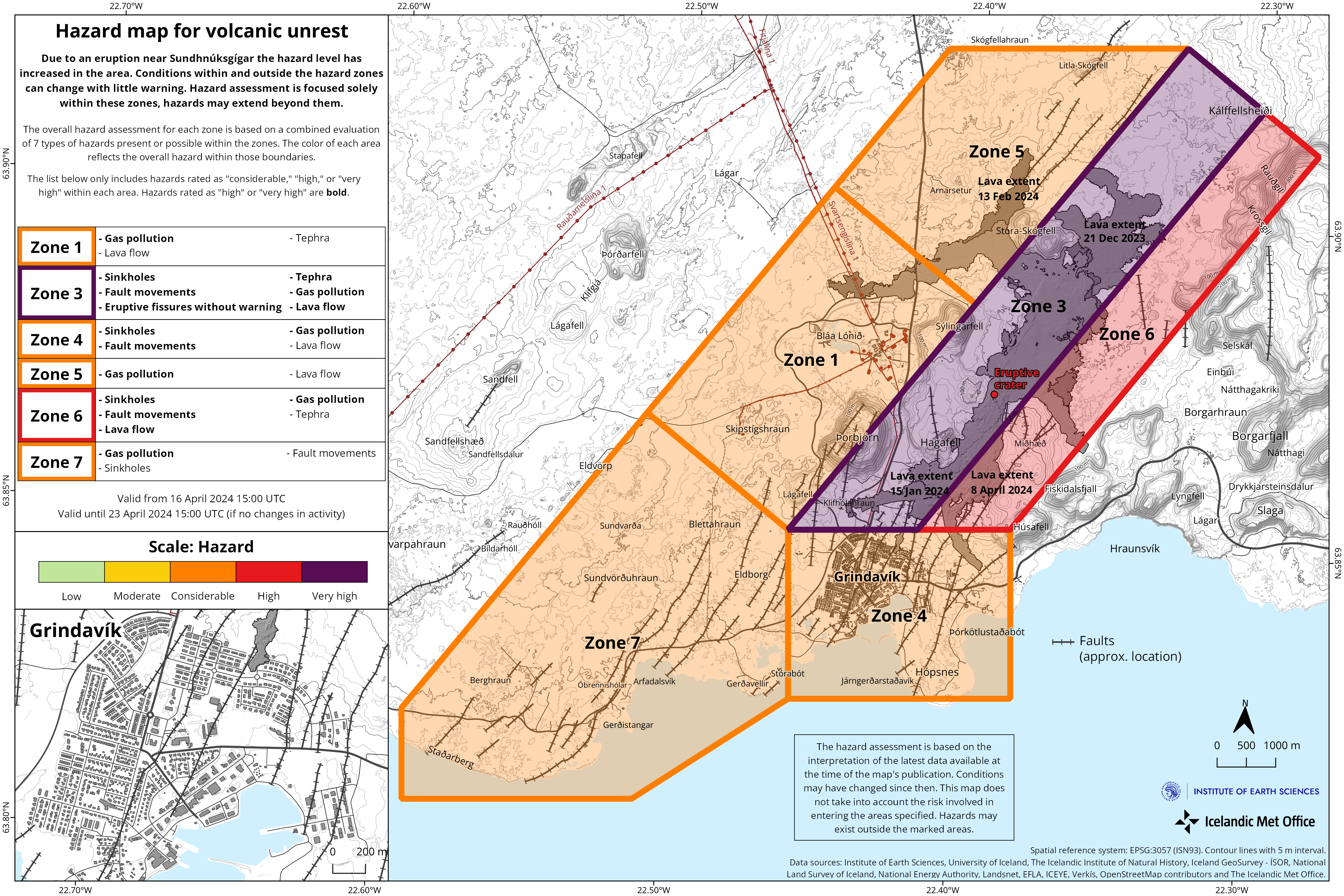
- The hazard assessment has been updated. The overall hazard for Grindavík (Zone 4) is estimated to be considerable (orange).
- Land uplift at Svartsengi continues, and the rate of uplift has been consistent since the beginning of April.
- Continued hazard due to gas pollution. People in the area are advised to check the air quality.
- The gas dispersion forecast can be found here.
- One crater, located east of Sundhnúkur, remains active.
The eruption at Sundhnúkur crater row continues and has now lasted for one month, as was the subject of a news report published earlier today. One crater, which is located just east of Sundhnúkur, continues to erupt. Lava still flows to the south of the crater but does not extend far, so the lava field continues to build up near the crater. There is an active lava field near Hagafell, as can be seen in an image from the Icelandic Meteorological Office‘s webcam located at Þorbjörn.
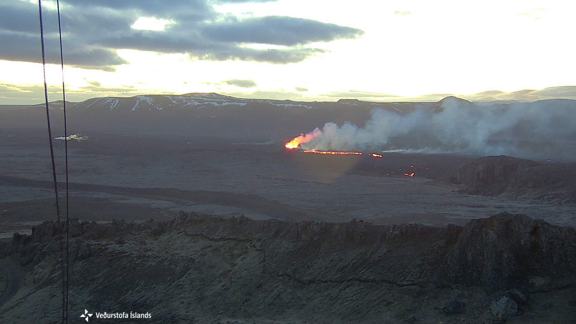 Image from the Icelandic Meteorological Office's webcam, taken at 5:10 AM, 16 April. The webcamera is located on top of Þorbjörn and looks east towards the eruption site. The crater is at the center of the image and lava flows from it. In front of the crater is Sundhnúkur, and on the right side of the image is Hagafell and lava flow fronts.
Seismic activity has been relatively calm near the eruption site since the beginning of the eruption until a small earthquake swarm began at Lágafell after noon on April 14. The seismic swarm lasted over 4 hours and has been associated with stress changes in the crust due to land uplift in Svartsengi. Seismic activity persists in the western slopes of Fagradalsfjall at 6-8 km depth and has been ongoing since the unrest in the Sundhnúkur area during the past 4 months.
Land uplift continues and has been at a steady rate since the beginning of April. Model calculations based on GPS data indicate that the inflow of magma into the magma reservoir is about half of what it was prior to the beginning of the eruption on March 16. This indicates that about half of the magma coming from depth is accumulating in the magma reservoir, while the other half is erupted to the surface.
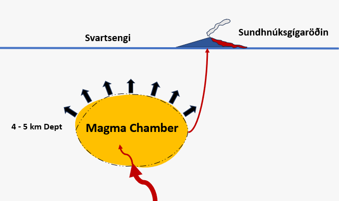 At the beginning of April, the rate of land uplift started to increase. Currently, a similar volume of magma is erupting onto the surface and also accumulating in the magma chamber beneath Svartsengi, causing a pressure increase in the magma chamber.
There continues to be a risk of gas emissions from the eruption, which can cause air pollution in settlements on the Reykjanes Peninsula, and we advise people in the area to monitor air quality and familiarize themselves with symptoms and responses related to air pollution from the eruption.
The weather forecast today (Tuesday) is a slow wind, variable direction. Thus, gas may accumulate near the eruption site. Tonight, winds will be southeasterly 10-15 m/s, carrying gas emissions northwest towards Reykjanesbær. West and northwesterly winds are expected to be 3-10 m/s tomorrow morning, dispersing gas east and southeast towards Þorlákshöfn. Follow the gas dispersion forecast here.
Hazard assessment
The hazards assessment has been updated and is valid from 15:00 today until 23 April barring any developments. The hazards assessment has changed so that the hazard due to lava flows has been lowered in all areas except in Zone 3 (Sundhnúkur crater row) and Zone 6. This change is being made because there has not been an active lava flow in the other areas in the last two weeks. Based on current activity in the eruption, it is estimated that lava is unlikely to flow far from the crater and into other hazard Zones. This change means that the overall hazard in Zone 4 (Grindavík) is now assessed as considerable (orange) instead of high (red). The overall hazard in other areas remains unchanged. The hazard from gas emissions continues to be assessed as high in all areas except at the Sundhnúkur crater row area (Zone 3) where it is assessed to be very high. The hazard in Zone 4 (Grindavík) and Zone 6 continues to be assessed as high due to sinkholes and fault movements.
 (Click on the image to see it larger)
- CreatedTuesday, April 16, 2024
- Last modifiedFriday, April 19, 2024
SUBSCRIBE
Sign up for our weekly newsletter and World News Trust project updates.

World Desk Activities

cpj.org/resources-for-journalists-covering-protest…

cpj.org/2020/09/guide-to-legal-rights-in-the-u-s/

pressfreedomtracker.us/submit-incident/

drive.google.com/file/d/17XyVCVOTq59bvTEG_RZAQMgrF…

www.icfj.org/news/new-icfj-knight-fellows-work-sup…

U.S.Justice Department: "Radical Right vs. Radical Left: Terrorist Theory and Threat"
www.ojp.gov/ncjrs/virtual-library/abstracts/radica….
ijnet.org/en/story/tips-building-networks-reach-au…

trustingnews.org/how-trustworthy-is-your-newsroom-…

Latest Stories


Electronic Frontier Foundation
- Coalition to Calexico: Think Twice About Reapproving Border Surveillance Tower Next to a Public Park May 14, 2024
- One (Busy) Day in the Life of EFF’s Activism Team May 14, 2024
- Speaking Freely: Mohamed El Gohary May 14, 2024
- Big Tech to EU: "Drop Dead" May 13, 2024
The Intercept
- This U.S. Attorney Resigned Amid an Ethics Investigation. Yet He Wound Up Overseeing Judges’ Ethics. May 14, 2024
- Pentagon Compensated Zero Civilian Victims in 2022 — Despite Evidence That the U.S. Killed a Mom and Child in Somalia May 13, 2024
- American Medical Missions Trapped in Gaza, Facing Death by Dehydration as Population Clings to Life May 13, 2024
- The Silence Around Covid Vaccine Injuries May 13, 2024
VTDigger
- Barre voters return Thom Lauzon to mayorship May 14, 2024
- Man charged with killing ex-girlfriend asks court to throw out his murder charge due to ‘insufficient’ evidence May 14, 2024
- Final Reading: It’s the last one, until 2025 May 14, 2024
- Open meeting carveout for Truth and Reconciliation Commission becomes law without Phil Scott’s signature May 14, 2024
