
Iceland Volcano: Warning Time Could Be Very Short Or Even None -- Iceland Met Office
Categories
Edited | All Content | Disasters | Earthquakes | Volcanos | Government | Science | Europe | Atlantic Ocean | News -- WNT Selected
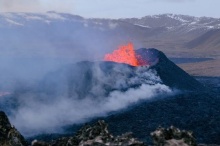
 Lava from the eruption 8 Feb. 2024. Photo: Birgir Vilhelm Óskarsson/The Icelandic Institute of Natural History.
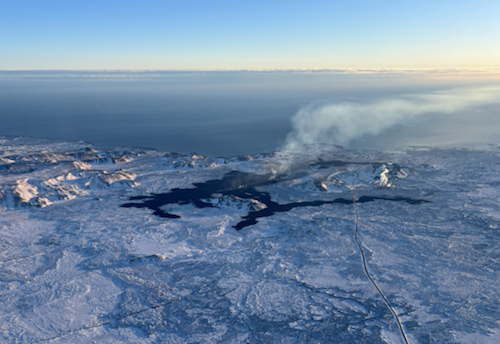
Magma volume under Svartsengi is reaching a level similar to before the last eruptions
Information is updated regularly here and on X (Formerly known as Twitter).
Updated 23. February at 15:00 UTC
Model calculations indicate that approximately 5 million cubic meters of magma had recharged to the Svartsengi reservoir as of 22 February. Considering the trend observed before previous volcanic eruptions in the Sundhnúkur crater row, the likelihood of an eruption is very high once the volume reaches between 8-13 million cubic meters (derived from joint InSAR-GNSS models). Based on the results of the model calculations, this could occur early next week if magma accumulation continues at the current rate.
It should be noted that there is a degree of uncertainty in this interpretation, and it cannot be assumed that the behavior will be identical to the past eruptions here. Also, as the magma plumbing system evolves, we cannot rule out the possibility that the volume of magma required to trigger a new diking event and/or eruption may become reduced.
Additionally, there is a possibility that magma could migrate from a dike intrusion occurs within this region without resulting in a volcanic eruption.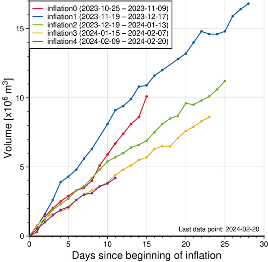 Figure: The graph displays a comparison of the volume of magma accumulated beneath Svartsengi before the magma flowed towards the Sundhnúkur crater row during the recent dike intrusions and eruptions that occurred between Dec. 2023 and Feb. 2024. The volume is calculated by a model based on GNSS data and is subject to uncertainty. Significant variations can also be observed between consecutive days. The current magma accumulation status as of Feb.22 is marked by the purple line. The red line shows the amount of magma accumulated before the major diking event beneath Grindavík on Nov. 10.
If an eruption occurs, scientists estimate that magma will most likely propagate from the reservoir beneath Svartsengi towards Sundhnúkur crater row, resulting in lava fountaining and lava flows in the area between Stóra-Skógfell and Hagafell. The primary signal of ascending magma is a sudden increase in seismic activity with many localized, small magnitude earthquakes. Considering the previous volcanic eruptions in the area, an eruption could start with very little warning (less than 30 minutes), depending on where magma reaches the surface on the Sundhnúkur crater row.
Likely scenarios
Eruption between Sýlingarfell and Stóra-Skógfell - As occurred on Dec. 18, 2023, and Feb. 8, 2024.
- Precursor: Sudden, localized, and intense seismic activity with small magnitude earthquakes. Deformation over the magma dike (if a dike is intruded) and the Svartsengi magma reservoir
- Very short warning time (less than 30 minutes) because a new dike propagation may not be required for magma to reach the surface. -Lava reaches Grindavík road in less than 4 hours.
Eruption by Hagafell – As occurred on Jan. 14, 2024.
- Precursor: Seismic activity with small magnitude earthquakes on the Sundhnúkur crater row, starting near Sýlingarfell and migrating south. Deformation over the magma dike and the Svartsengi magma reservoir
- Likely warning time is approximately 1-3 hours from the detection of the first earthquakes until the start of an eruption.
- Lava reaches the lava barriers around Grindavík within 1 hour.
- Magma intrusion, which reaches south of Hagafell, will likely cause significant fault movements in Grindavík
Eruption inside of the lava barriers around Grindavík
- Seismic activity with small magnitude earthquakes on the Sundhnúkur crater row, starting near Sýlingarfell and migrating south. Deformation over the magma dike and the Svartsengi magma reservoir
- Probable warning time is between approximately 1-5 hours from the detection of the first earthquakes until the start of an eruption.
- An eruptive fissure/s may open within Grindavík or the region just north of here (inside the barriers). Similar activity occurred on 14 Jan. when a volcanic fissure opened just inside the outer perimeter of the town approximately 4 hours after the onset of the eruption near Hagafell.
- Magma intrusion, which reaches south of Grindavík, will cause significant fault movements in Grindavík.
Although there is a clear indication of uplift in the Svartsengi-Þórbjörn area (related to magma recharge of this reservoir) this does not mean that it is the most likely location for an eruption to start. This is because the magma reservoir is currently failing on its northeastern edge feeding dike propagations which are initiated between Stóra-Skógfell- and Sundhnúkur crater row. In a scenario where magma ascends towards the surface directly from the Svartsengi reservoir, it is estimated that the first signs of magma migration would be detected 4-7 hours before magma reaches the surface.
Please note that these scenarios are based on interpretations of the latest data and the observed development of the previous events at the Sundhnúkur crater row area. Uncertainty must be accounted for in this interpretation, as it is only based on a few events.
Updated 23. February at 9:30 UTC
Seismic activity in the unrest area north of Grindavík remains minimal. About 20 small earthquakes have been detected on a 24-hour basis for the past days.
Magma accumulation beneath Svartsengi continues and the pace of the accumulation has been quite steady. This is a similar trend as has been observed before the previous volcanic eruptions.
The event which started at the end of October 2023 with an inflation at Svartsengi thus continues. Whilst magma accumulation persists, another volcanic eruption is expected in similar areas as before.
Should magma accumulation continue at the current pace, the amount will reach a threshold believed necessary to trigger a dyke propagation and even an eruption, by next week. The amount of magma accumulated beneath Svartsengi before previous eruptions is estimated to have been 8-13 million m3. New model calculations are underway to obtain a better understanding of how much magma has now been accumulated.
At the moment, it is not considered necessary to raise the hazard level in the area and thus the hazard assessment issued by IMO remains unchanged.
The hazard assessment will be updated on Monday 26 Feb. and should the development continue at a similar rate as now, hazard levels in zones will be raised as more magma will accumulate and thus there is a higher likelihood of an eruption.
 (Click on the map to see it larger)
- CreatedFriday, February 23, 2024
- Last modifiedTuesday, February 27, 2024
SUBSCRIBE
Sign up for our weekly newsletter and World News Trust project updates.

World Desk Activities

cpj.org/resources-for-journalists-covering-protest…

cpj.org/2020/09/guide-to-legal-rights-in-the-u-s/

pressfreedomtracker.us/submit-incident/

drive.google.com/file/d/17XyVCVOTq59bvTEG_RZAQMgrF…

www.icfj.org/news/new-icfj-knight-fellows-work-sup…

U.S.Justice Department: "Radical Right vs. Radical Left: Terrorist Theory and Threat"
www.ojp.gov/ncjrs/virtual-library/abstracts/radica….
ijnet.org/en/story/tips-building-networks-reach-au…

trustingnews.org/how-trustworthy-is-your-newsroom-…

Latest Stories


Electronic Frontier Foundation
- Fair Use Still Protects Histories and Documentaries—Even Tiger King May 15, 2024
- The Cybertiger Strikes Again! EFF's 8th Annual Tech Trivia Night May 15, 2024
- Coalition to Calexico: Think Twice About Reapproving Border Surveillance Tower Next to a Public Park May 14, 2024
- One (Busy) Day in the Life of EFF’s Activism Team May 14, 2024
The Intercept
- An Israeli Company Is Hawking Its Self-Launching Drone System to U.S. Police Departments May 17, 2024
- The Consumer Finance Protection Bureau Is Constitutional, After All May 16, 2024
- Outside Groups Spent $285,000 Backing Jamaal Bowman. AIPAC Alone Just Dropped Nearly $2 Million to Attack Him. May 16, 2024
- Republicans Can't Decide: Do They Hate Prosecutors Because of Bail Reform or Abortion? May 16, 2024
VTDigger
- Dartmouth president’s leadership divides students; ‘no confidence’ narrowly passes May 17, 2024
- Drew Lalumiere May 16, 2024
- Robert Howard Rodgers May 16, 2024
- Former executive for medical records firm gets probation for trying to obstruct opioid kickback probe May 16, 2024
